You are here: Home > Network List > US - United States National Seismic Network Stations List
> Station EGMT Eagleton, Montana, USA > Earthquake Result Viewer
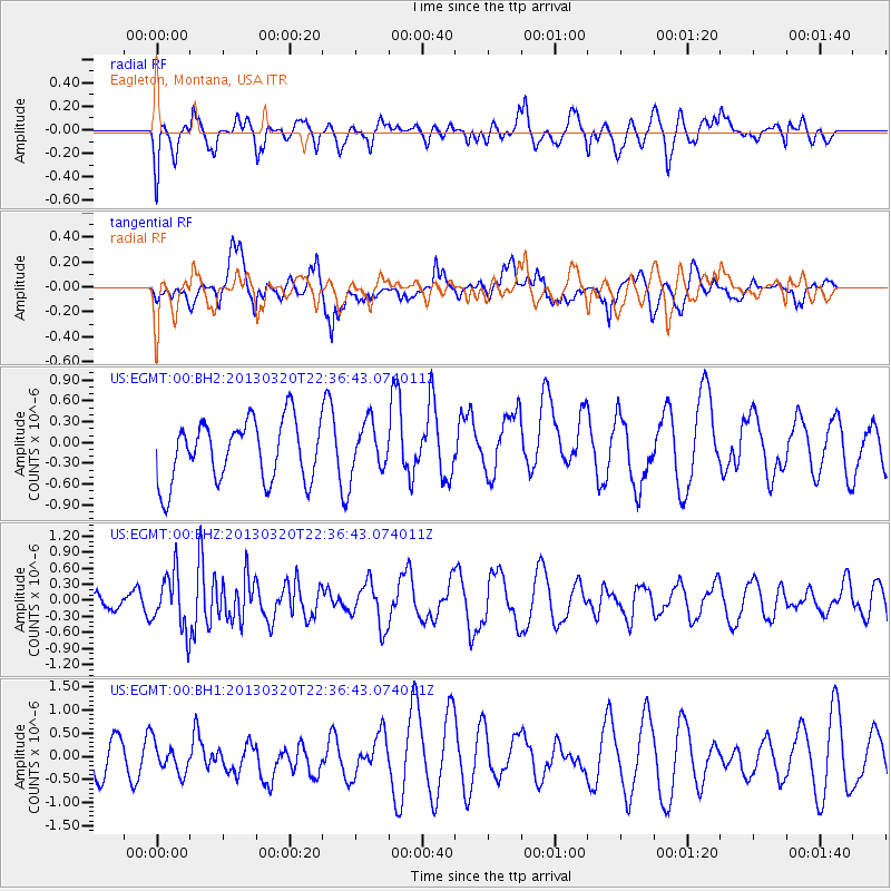
EGMT Eagleton, Montana, USA - Earthquake Result Viewer
*The percent match for this event was below the threshold and hence no stack was calculated.
| Earthquake location: |
Reykjanes Ridge |
| Earthquake latitude/longitude: |
55.5/-34.9 |
| Earthquake time(UTC): |
2013/03/20 (079) 22:29:00 GMT |
| Earthquake Depth: |
10 km |
| Earthquake Magnitude: |
5.5 MW |
| Earthquake Catalog/Contributor: |
NEIC PDE/NEIC PDE-W |
|
| Network: |
US United States National Seismic Network |
| Station: |
EGMT Eagleton, Montana, USA |
| Lat/Lon: |
48.02 N/109.75 W |
| Elevation: |
1055 m |
|
| Distance: |
44.8 deg |
| Az: |
293.152 deg |
| Baz: |
51.196 deg |
| Ray Param: |
$rayparam |
*The percent match for this event was below the threshold and hence was not used in the summary stack. |
|
| Radial Match: |
51.33037 % |
| Radial Bump: |
400 |
| Transverse Match: |
59.56856 % |
| Transverse Bump: |
400 |
| SOD ConfigId: |
558545 |
| Insert Time: |
2013-09-18 09:39:02.309 +0000 |
| GWidth: |
2.5 |
| Max Bumps: |
400 |
| Tol: |
0.001 |
|
Signal To Noise
| Channel | StoN | STA | LTA |
| US:EGMT:00:BHZ:20130320T22:36:43.074011Z | 2.5503712 | 5.2210487E-7 | 2.0471722E-7 |
| US:EGMT:00:BH1:20130320T22:36:43.074011Z | 0.8011703 | 3.3387482E-7 | 4.167339E-7 |
| US:EGMT:00:BH2:20130320T22:36:43.074011Z | 0.79511356 | 3.458811E-7 | 4.3500842E-7 |
| Arrivals |
| Ps | |
| PpPs | |
| PsPs/PpSs | |


