You are here: Home > Network List > IU - Global Seismograph Network (GSN - IRIS/USGS) Stations List
> Station PMG Port Moresby, New Guinea > Earthquake Result Viewer
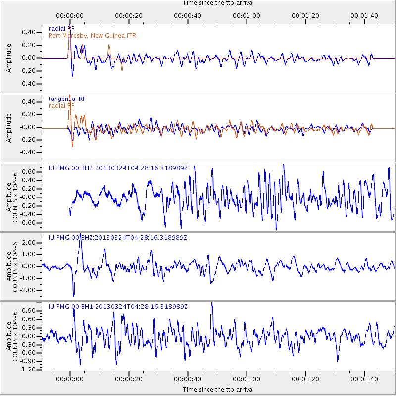
PMG Port Moresby, New Guinea - Earthquake Result Viewer
*The percent match for this event was below the threshold and hence no stack was calculated.
| Earthquake location: |
East Of Kuril Islands |
| Earthquake latitude/longitude: |
50.7/160.2 |
| Earthquake time(UTC): |
2013/03/24 (083) 04:18:33 GMT |
| Earthquake Depth: |
8.0 km |
| Earthquake Magnitude: |
6.1 MB, 5.5 MS, 5.9 MW, 6.1 MW |
| Earthquake Catalog/Contributor: |
WHDF/NEIC |
|
| Network: |
IU Global Seismograph Network (GSN - IRIS/USGS) |
| Station: |
PMG Port Moresby, New Guinea |
| Lat/Lon: |
9.40 S/147.16 E |
| Elevation: |
90 m |
|
| Distance: |
60.9 deg |
| Az: |
194.709 deg |
| Baz: |
9.412 deg |
| Ray Param: |
$rayparam |
*The percent match for this event was below the threshold and hence was not used in the summary stack. |
|
| Radial Match: |
77.96834 % |
| Radial Bump: |
400 |
| Transverse Match: |
69.8387 % |
| Transverse Bump: |
400 |
| SOD ConfigId: |
558545 |
| Insert Time: |
2013-09-18 09:43:47.473 +0000 |
| GWidth: |
2.5 |
| Max Bumps: |
400 |
| Tol: |
0.001 |
|
Signal To Noise
| Channel | StoN | STA | LTA |
| IU:PMG:00:BHZ:20130324T04:28:16.318989Z | 11.000533 | 1.2586426E-6 | 1.144165E-7 |
| IU:PMG:00:BH1:20130324T04:28:16.318989Z | 3.1593053 | 4.6255363E-7 | 1.4640992E-7 |
| IU:PMG:00:BH2:20130324T04:28:16.318989Z | 1.5135462 | 2.4749534E-7 | 1.6352017E-7 |
| Arrivals |
| Ps | |
| PpPs | |
| PsPs/PpSs | |


