You are here: Home > Network List > US - United States National Seismic Network Stations List
> Station AGMN Agassiz National Wildlife Refuge, Minnesota, USA > Earthquake Result Viewer
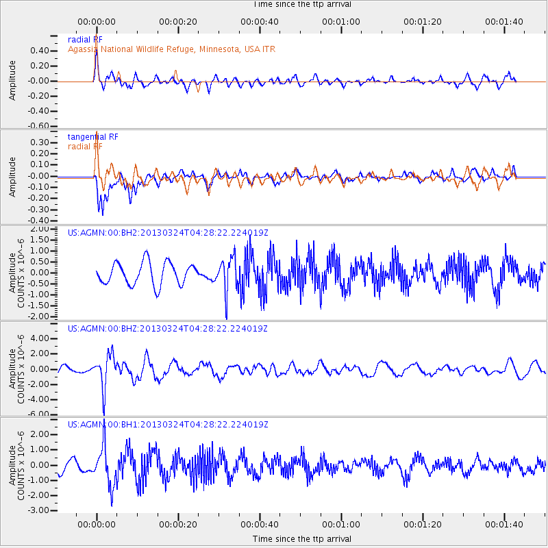
AGMN Agassiz National Wildlife Refuge, Minnesota, USA - Earthquake Result Viewer
*The percent match for this event was below the threshold and hence no stack was calculated.
| Earthquake location: |
East Of Kuril Islands |
| Earthquake latitude/longitude: |
50.7/160.2 |
| Earthquake time(UTC): |
2013/03/24 (083) 04:18:33 GMT |
| Earthquake Depth: |
8.0 km |
| Earthquake Magnitude: |
6.1 MB, 5.5 MS, 5.9 MW, 6.1 MW |
| Earthquake Catalog/Contributor: |
WHDF/NEIC |
|
| Network: |
US United States National Seismic Network |
| Station: |
AGMN Agassiz National Wildlife Refuge, Minnesota, USA |
| Lat/Lon: |
48.30 N/95.86 W |
| Elevation: |
351 m |
|
| Distance: |
61.8 deg |
| Az: |
47.315 deg |
| Baz: |
315.605 deg |
| Ray Param: |
$rayparam |
*The percent match for this event was below the threshold and hence was not used in the summary stack. |
|
| Radial Match: |
72.03799 % |
| Radial Bump: |
400 |
| Transverse Match: |
73.14435 % |
| Transverse Bump: |
400 |
| SOD ConfigId: |
558545 |
| Insert Time: |
2013-09-18 09:44:54.202 +0000 |
| GWidth: |
2.5 |
| Max Bumps: |
400 |
| Tol: |
0.001 |
|
Signal To Noise
| Channel | StoN | STA | LTA |
| US:AGMN:00:BHZ:20130324T04:28:22.224019Z | 3.1445265 | 2.1568278E-6 | 6.8589907E-7 |
| US:AGMN:00:BH1:20130324T04:28:22.224019Z | 3.4704816 | 1.2808239E-6 | 3.6906226E-7 |
| US:AGMN:00:BH2:20130324T04:28:22.224019Z | 1.5155606 | 7.537623E-7 | 4.973488E-7 |
| Arrivals |
| Ps | |
| PpPs | |
| PsPs/PpSs | |


