You are here: Home > Network List > US - United States National Seismic Network Stations List
> Station DGMT Dagmar, Montana, USA > Earthquake Result Viewer
DGMT Dagmar, Montana, USA - Earthquake Result Viewer

| Earthquake location: |
East Of Kuril Islands |
| Earthquake latitude/longitude: |
50.7/160.2 |
| Earthquake time(UTC): |
2013/03/24 (083) 04:18:33 GMT |
| Earthquake Depth: |
8.0 km |
| Earthquake Magnitude: |
6.1 MB, 5.5 MS, 5.9 MW, 6.1 MW |
| Earthquake Catalog/Contributor: |
WHDF/NEIC |
|
| Network: |
US United States National Seismic Network |
| Station: |
DGMT Dagmar, Montana, USA |
| Lat/Lon: |
48.47 N/104.20 W |
| Elevation: |
0.0 m |
|
| Distance: |
57.7 deg |
| Az: |
51.601 deg |
| Baz: |
311.549 deg |
| Ray Param: |
0.06334249 |
| Estimated Moho Depth: |
23.0 km |
| Estimated Crust Vp/Vs: |
1.75 |
| Assumed Crust Vp: |
6.438 km/s |
| Estimated Crust Vs: |
3.684 km/s |
| Estimated Crust Poisson's Ratio: |
0.26 |
|
| Radial Match: |
81.27128 % |
| Radial Bump: |
346 |
| Transverse Match: |
54.637672 % |
| Transverse Bump: |
312 |
| SOD ConfigId: |
558545 |
| Insert Time: |
2013-09-18 09:45:24.996 +0000 |
| GWidth: |
2.5 |
| Max Bumps: |
400 |
| Tol: |
0.001 |
|
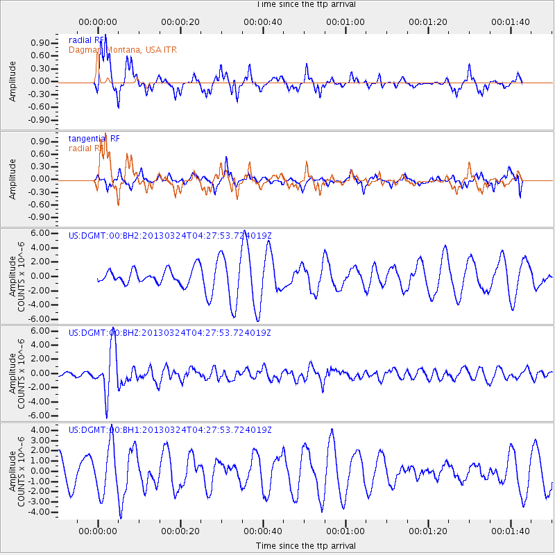
Signal To Noise
| Channel | StoN | STA | LTA |
| US:DGMT:00:BHZ:20130324T04:27:53.724019Z | 11.577364 | 3.4657578E-6 | 2.993564E-7 |
| US:DGMT:00:BH1:20130324T04:27:53.724019Z | 1.9942932 | 2.392433E-6 | 1.1996395E-6 |
| US:DGMT:00:BH2:20130324T04:27:53.724019Z | 3.5131426 | 3.4833492E-6 | 9.915194E-7 |
| Arrivals |
| Ps | 2.8 SECOND |
| PpPs | 9.3 SECOND |
| PsPs/PpSs | 12 SECOND |


