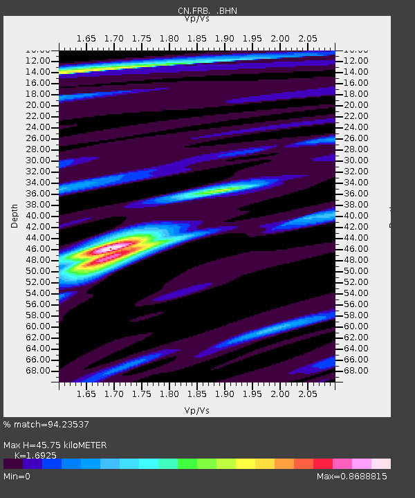
FRB IQALUIT, N.W.T. - Earthquake Result Viewer

Earthquake location: Fox Islands, Aleutian Islands
Earthquake latitude/longitude: 52.9/-169.1
Earthquake time(UTC): 1999/01/28 (028) 08:10:05 GMT
Earthquake Depth: 67 km
Earthquake Magnitude: 6.3 MB, 6.1 MS, 6.6 MW, 6.6 ME
Earthquake Catalog/Contributor: WHDF/NEIC
Network: CN Canadian National Seismograph Network
Station: FRB IQALUIT, N.W.T.
Lat/Lon: 63.75 N/68.55 W
Elevation: 18 m
Distance: 48.5 deg
Az: 35.732 deg
Baz: 307.276 deg
Ray Param: 0.06913669
Estimated Moho Depth: 45.75 km
Estimated Crust Vp/Vs: 1.69
Assumed Crust Vp: 6.419 km/s
Estimated Crust Vs: 3.793 km/s
Estimated Crust Poisson's Ratio: 0.23
Radial Match: 94.23537 %
Radial Bump: 283
Transverse Match: 67.6696 %
Transverse Bump: 400
SOD ConfigId: 4480
Insert Time: 2010-02-27 05:42:31.802 +0000
GWidth: 2.5
Max Bumps: 400
Tol: 0.001

Signal To Noise

ChannelStoNSTALTA
CN:FRB: :BHN:19990128T08:18:10.74901Z19.887723.5948792E-61.8075873E-7
CN:FRB: :BHE:19990128T08:18:10.74901Z8.0326171.4154754E-61.7621598E-7
CN:FRB: :BHZ:19990128T08:18:10.74901Z10.8794661.5056258E-61.3839153E-7
Arrivals
Ps5.3 SECOND
PpPs18 SECOND
PsPs/PpSs23 SECOND