You are here: Home > Network List > UW - Pacific Northwest Regional Seismic Network Stations List
> Station LEBA Lebam, WA, USA > Earthquake Result Viewer
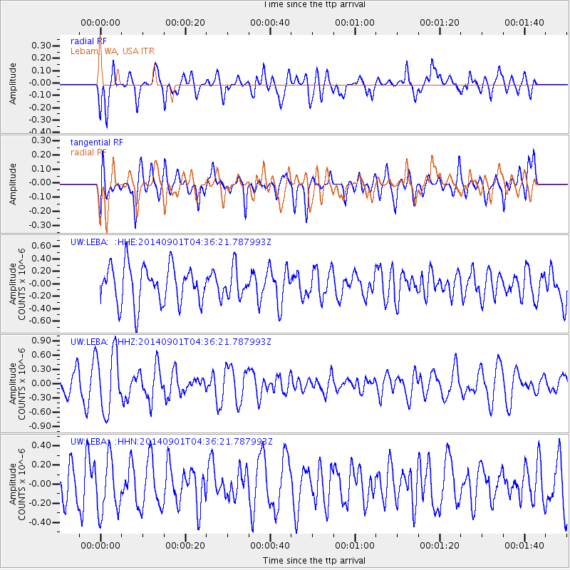
LEBA Lebam, WA, USA - Earthquake Result Viewer
*The percent match for this event was below the threshold and hence no stack was calculated.
| Earthquake location: |
South Of Tonga Islands |
| Earthquake latitude/longitude: |
-24.9/-175.8 |
| Earthquake time(UTC): |
2014/09/01 (244) 04:24:16 GMT |
| Earthquake Depth: |
12 km |
| Earthquake Magnitude: |
5.3 MW |
| Earthquake Catalog/Contributor: |
ISC/ISC |
|
| Network: |
UW Pacific Northwest Regional Seismic Network |
| Station: |
LEBA Lebam, WA, USA |
| Lat/Lon: |
46.55 N/123.56 W |
| Elevation: |
73 m |
|
| Distance: |
85.4 deg |
| Az: |
33.177 deg |
| Baz: |
226.032 deg |
| Ray Param: |
$rayparam |
*The percent match for this event was below the threshold and hence was not used in the summary stack. |
|
| Radial Match: |
68.88158 % |
| Radial Bump: |
400 |
| Transverse Match: |
47.192314 % |
| Transverse Bump: |
400 |
| SOD ConfigId: |
3390531 |
| Insert Time: |
2019-04-13 18:29:22.663 +0000 |
| GWidth: |
2.5 |
| Max Bumps: |
400 |
| Tol: |
0.001 |
|
Signal To Noise
| Channel | StoN | STA | LTA |
| UW:LEBA: :HHZ:20140901T04:36:21.787993Z | 3.2091146 | 6.1950504E-7 | 1.9304548E-7 |
| UW:LEBA: :HHN:20140901T04:36:21.787993Z | 1.3472083 | 2.8715115E-7 | 2.1314534E-7 |
| UW:LEBA: :HHE:20140901T04:36:21.787993Z | 0.7654926 | 2.3223838E-7 | 3.033842E-7 |
| Arrivals |
| Ps | |
| PpPs | |
| PsPs/PpSs | |


