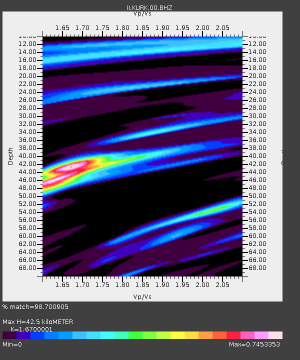
KURK Kurchatov, Kazakhstan - Earthquake Result Viewer

Earthquake location: Near East Coast Of Honshu, Japan
Earthquake latitude/longitude: 38.4/142.8
Earthquake time(UTC): 2011/03/09 (068) 02:45:20 GMT
Earthquake Depth: 32 km
Earthquake Magnitude: 6.4 MB, 7.3 MS, 7.5 MW, 7.3 MW
Earthquake Catalog/Contributor: WHDF/NEIC
Network: II Global Seismograph Network (GSN - IRIS/IDA)
Station: KURK Kurchatov, Kazakhstan
Lat/Lon: 50.72 N/78.62 E
Elevation: 184 m
Distance: 46.0 deg
Az: 307.235 deg
Baz: 79.591 deg
Ray Param: 0.07087166
Estimated Moho Depth: 42.5 km
Estimated Crust Vp/Vs: 1.67
Assumed Crust Vp: 6.552 km/s
Estimated Crust Vs: 3.924 km/s
Estimated Crust Poisson's Ratio: 0.22
Radial Match: 98.700905 %
Radial Bump: 260
Transverse Match: 88.7855 %
Transverse Bump: 400
SOD ConfigId: 558545
Insert Time: 2013-09-18 10:24:56.223 +0000
GWidth: 2.5
Max Bumps: 400
Tol: 0.001

Signal To Noise

ChannelStoNSTALTA
II:KURK:00:BHZ:20110309T02:53:09.845015Z40.9438671.0727235E-52.619986E-7
II:KURK:00:BH1:20110309T02:53:09.845015Z4.6002598.6653773E-71.8836717E-7
II:KURK:00:BH2:20110309T02:53:09.845015Z21.3310055.5751557E-62.6136394E-7
Arrivals
Ps4.7 SECOND
PpPs16 SECOND
PsPs/PpSs21 SECOND