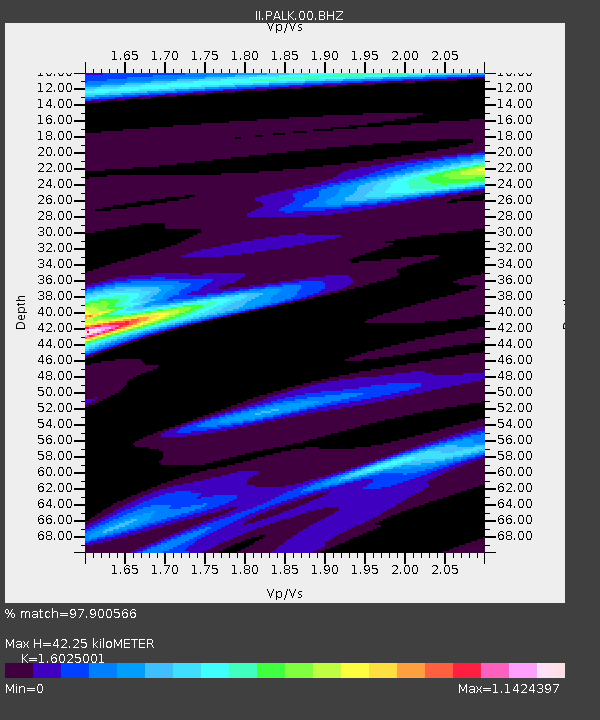
PALK Pallekele, Sri Lanka - Earthquake Result Viewer
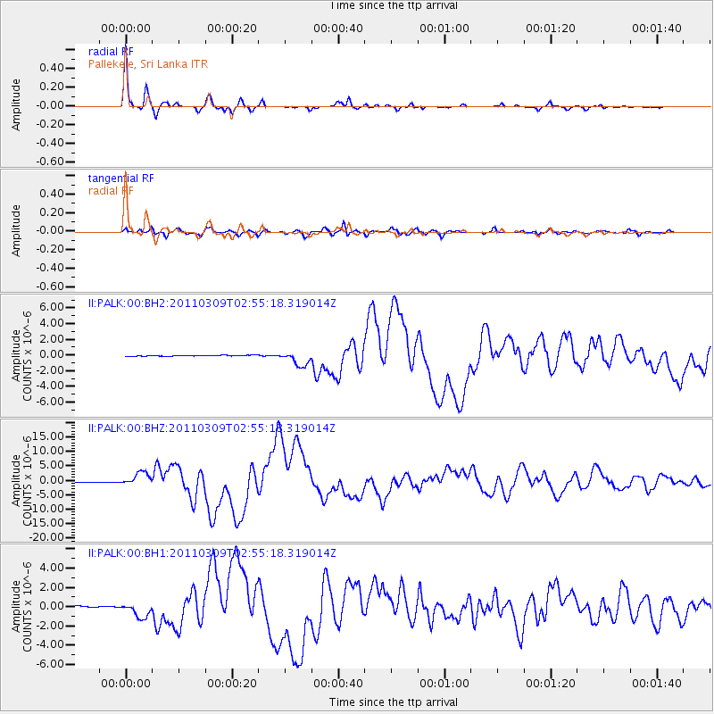
Earthquake location: Near East Coast Of Honshu, Japan
Earthquake latitude/longitude: 38.4/142.8
Earthquake time(UTC): 2011/03/09 (068) 02:45:20 GMT
Earthquake Depth: 32 km
Earthquake Magnitude: 6.4 MB, 7.3 MS, 7.5 MW, 7.3 MW
Earthquake Catalog/Contributor: WHDF/NEIC
Network: II Global Seismograph Network (GSN - IRIS/IDA)
Station: PALK Pallekele, Sri Lanka
Lat/Lon: 7.27 N/80.70 E
Elevation: 460 m
Distance: 63.8 deg
Az: 257.887 deg
Baz: 50.715 deg
Ray Param: 0.05930732
Estimated Moho Depth: 42.25 km
Estimated Crust Vp/Vs: 1.60
Assumed Crust Vp: 6.545 km/s
Estimated Crust Vs: 4.084 km/s
Estimated Crust Poisson's Ratio: 0.18
Radial Match: 97.900566 %
Radial Bump: 242
Transverse Match: 90.121994 %
Transverse Bump: 400
SOD ConfigId: 558545
Insert Time: 2013-09-18 10:25:00.687 +0000
GWidth: 2.5
Max Bumps: 400
Tol: 0.001

Signal To Noise

ChannelStoNSTALTA
II:PALK:00:BHZ:20110309T02:55:18.319014Z25.2893582.4150595E-69.5497064E-8
II:PALK:00:BH1:20110309T02:55:18.319014Z13.0812437.89641E-76.036437E-8
II:PALK:00:BH2:20110309T02:55:18.319014Z15.2636449.226147E-76.044524E-8
Arrivals
Ps4.1 SECOND
PpPs16 SECOND
PsPs/PpSs20 SECOND