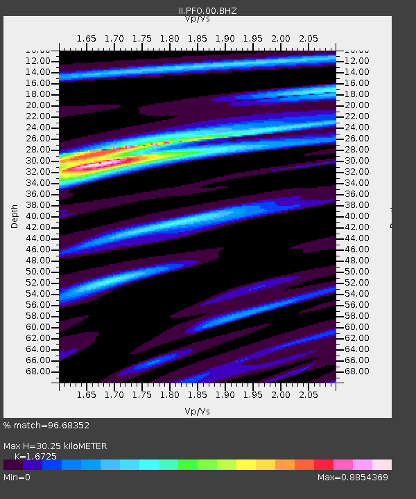
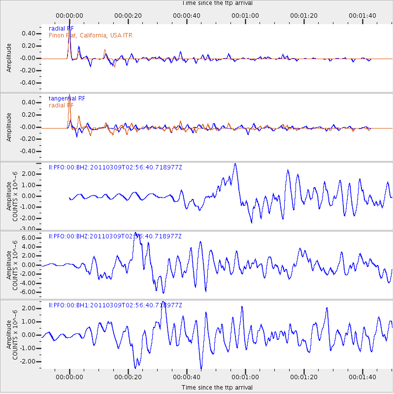
PFO Pinon Flat, California, USA - Earthquake Result Viewer

Earthquake location: Near East Coast Of Honshu, Japan
Earthquake latitude/longitude: 38.4/142.8
Earthquake time(UTC): 2011/03/09 (068) 02:45:20 GMT
Earthquake Depth: 32 km
Earthquake Magnitude: 6.4 MB, 7.3 MS, 7.5 MW, 7.3 MW
Earthquake Catalog/Contributor: WHDF/NEIC
Network: II Global Seismograph Network (GSN - IRIS/IDA)
Station: PFO Pinon Flat, California, USA
Lat/Lon: 33.61 N/116.46 W
Elevation: 1280 m
Distance: 77.3 deg
Az: 57.191 deg
Baz: 307.726 deg
Ray Param: 0.050353162
Estimated Moho Depth: 30.25 km
Estimated Crust Vp/Vs: 1.67
Assumed Crust Vp: 6.264 km/s
Estimated Crust Vs: 3.745 km/s
Estimated Crust Poisson's Ratio: 0.22
Radial Match: 96.68352 %
Radial Bump: 258
Transverse Match: 81.046684 %
Transverse Bump: 396
SOD ConfigId: 558545
Insert Time: 2013-09-18 10:25:01.938 +0000
GWidth: 2.5
Max Bumps: 400
Tol: 0.001

Signal To Noise

ChannelStoNSTALTA
II:PFO:00:BHZ:20110309T02:56:40.718977Z1.43156023.5242851E-72.461849E-7
II:PFO:00:BH1:20110309T02:56:40.718977Z0.55004241.2938922E-72.35235E-7
II:PFO:00:BH2:20110309T02:56:40.718977Z0.462833588.428409E-81.8210451E-7
Arrivals
Ps3.3 SECOND
PpPs13 SECOND
PsPs/PpSs16 SECOND