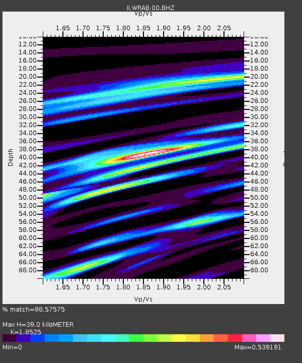
WRAB Tennant Creek, NT, Australia - Earthquake Result Viewer
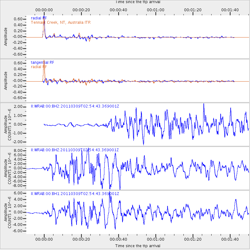
Earthquake location: Near East Coast Of Honshu, Japan
Earthquake latitude/longitude: 38.4/142.8
Earthquake time(UTC): 2011/03/09 (068) 02:45:20 GMT
Earthquake Depth: 32 km
Earthquake Magnitude: 6.4 MB, 7.3 MS, 7.5 MW, 7.3 MW
Earthquake Catalog/Contributor: WHDF/NEIC
Network: II Global Seismograph Network (GSN - IRIS/IDA)
Station: WRAB Tennant Creek, NT, Australia
Lat/Lon: 19.93 S/134.36 E
Elevation: 366 m
Distance: 58.6 deg
Az: 189.356 deg
Baz: 7.8 deg
Ray Param: 0.06268262
Estimated Moho Depth: 39.0 km
Estimated Crust Vp/Vs: 1.85
Assumed Crust Vp: 6.642 km/s
Estimated Crust Vs: 3.585 km/s
Estimated Crust Poisson's Ratio: 0.29
Radial Match: 98.57575 %
Radial Bump: 217
Transverse Match: 89.25778 %
Transverse Bump: 400
SOD ConfigId: 558545
Insert Time: 2013-09-18 10:25:11.322 +0000
GWidth: 2.5
Max Bumps: 400
Tol: 0.001

Signal To Noise

ChannelStoNSTALTA
II:WRAB:00:BHZ:20110309T02:54:43.369001Z19.2361151.6112645E-68.376247E-8
II:WRAB:00:BH1:20110309T02:54:43.369001Z9.6710318.399704E-78.685428E-8
II:WRAB:00:BH2:20110309T02:54:43.369001Z1.05752069.875812E-89.3386475E-8
Arrivals
Ps5.3 SECOND
PpPs16 SECOND
PsPs/PpSs21 SECOND