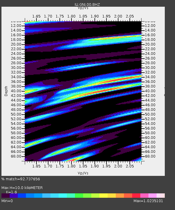
GNI Garni, Armenia - Earthquake Result Viewer

Earthquake location: Near East Coast Of Honshu, Japan
Earthquake latitude/longitude: 38.4/142.8
Earthquake time(UTC): 2011/03/09 (068) 02:45:20 GMT
Earthquake Depth: 32 km
Earthquake Magnitude: 6.4 MB, 7.3 MS, 7.5 MW, 7.3 MW
Earthquake Catalog/Contributor: WHDF/NEIC
Network: IU Global Seismograph Network (GSN - IRIS/USGS)
Station: GNI Garni, Armenia
Lat/Lon: 40.15 N/44.74 E
Elevation: 1609 m
Distance: 71.8 deg
Az: 306.971 deg
Baz: 54.942 deg
Ray Param: 0.054055925
Estimated Moho Depth: 10.0 km
Estimated Crust Vp/Vs: 1.60
Assumed Crust Vp: 6.291 km/s
Estimated Crust Vs: 3.932 km/s
Estimated Crust Poisson's Ratio: 0.18
Radial Match: 92.737656 %
Radial Bump: 400
Transverse Match: 87.36627 %
Transverse Bump: 400
SOD ConfigId: 558545
Insert Time: 2013-09-18 10:25:28.033 +0000
GWidth: 2.5
Max Bumps: 400
Tol: 0.001

Signal To Noise

ChannelStoNSTALTA
IU:GNI:00:BHZ:20110309T02:56:08.569014Z21.9389673.7562365E-61.71213E-7
IU:GNI:00:BH1:20110309T02:56:08.569014Z7.1281641.0178939E-61.4279888E-7
IU:GNI:00:BH2:20110309T02:56:08.569014Z6.97860671.1007003E-61.5772493E-7
Arrivals
Ps1.0 SECOND
PpPs4.0 SECOND
PsPs/PpSs5.0 SECOND