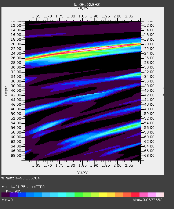
KEV Kevo, Finland - Earthquake Result Viewer

Earthquake location: Near East Coast Of Honshu, Japan
Earthquake latitude/longitude: 38.4/142.8
Earthquake time(UTC): 2011/03/09 (068) 02:45:20 GMT
Earthquake Depth: 32 km
Earthquake Magnitude: 6.4 MB, 7.3 MS, 7.5 MW, 7.3 MW
Earthquake Catalog/Contributor: WHDF/NEIC
Network: IU Global Seismograph Network (GSN - IRIS/USGS)
Station: KEV Kevo, Finland
Lat/Lon: 69.76 N/27.00 E
Elevation: 100 m
Distance: 62.5 deg
Az: 339.325 deg
Baz: 52.808 deg
Ray Param: 0.060110576
Estimated Moho Depth: 21.75 km
Estimated Crust Vp/Vs: 1.90
Assumed Crust Vp: 6.622 km/s
Estimated Crust Vs: 3.476 km/s
Estimated Crust Poisson's Ratio: 0.31
Radial Match: 93.135704 %
Radial Bump: 263
Transverse Match: 60.08688 %
Transverse Bump: 400
SOD ConfigId: 558545
Insert Time: 2013-09-18 10:25:37.817 +0000
GWidth: 2.5
Max Bumps: 400
Tol: 0.001

Signal To Noise

ChannelStoNSTALTA
IU:KEV:00:BHZ:20110309T02:55:10.119001Z3.13538244.0202876E-61.282232E-6
IU:KEV:00:BH1:20110309T02:55:10.119001Z1.4879541.2861002E-68.6434136E-7
IU:KEV:00:BH2:20110309T02:55:10.119001Z2.79431722.0898362E-67.4788795E-7
Arrivals
Ps3.1 SECOND
PpPs9.1 SECOND
PsPs/PpSs12 SECOND