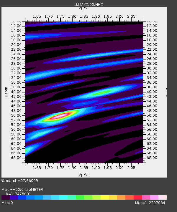
MAKZ Makanchi, Kazakhstan - Earthquake Result Viewer
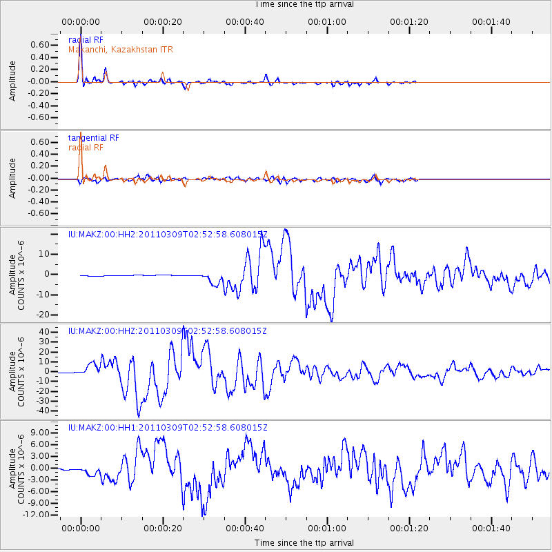
Earthquake location: Near East Coast Of Honshu, Japan
Earthquake latitude/longitude: 38.4/142.8
Earthquake time(UTC): 2011/03/09 (068) 02:45:20 GMT
Earthquake Depth: 32 km
Earthquake Magnitude: 6.4 MB, 7.3 MS, 7.5 MW, 7.3 MW
Earthquake Catalog/Contributor: WHDF/NEIC
Network: IU Global Seismograph Network (GSN - IRIS/USGS)
Station: MAKZ Makanchi, Kazakhstan
Lat/Lon: 46.81 N/81.98 E
Elevation: 600 m
Distance: 44.6 deg
Az: 301.226 deg
Baz: 77.878 deg
Ray Param: 0.07178233
Estimated Moho Depth: 50.0 km
Estimated Crust Vp/Vs: 1.75
Assumed Crust Vp: 6.571 km/s
Estimated Crust Vs: 3.76 km/s
Estimated Crust Poisson's Ratio: 0.26
Radial Match: 97.66009 %
Radial Bump: 321
Transverse Match: 84.94363 %
Transverse Bump: 400
SOD ConfigId: 558545
Insert Time: 2013-09-18 10:25:43.187 +0000
GWidth: 2.5
Max Bumps: 400
Tol: 0.001

Signal To Noise

ChannelStoNSTALTA
IU:MAKZ:00:HHZ:20110309T02:52:58.608015Z29.0579266.308944E-62.1711612E-7
IU:MAKZ:00:HH1:20110309T02:52:58.608015Z7.2173491.0314419E-61.4291146E-7
IU:MAKZ:00:HH2:20110309T02:52:58.608015Z17.6739753.2067267E-61.8143777E-7
Arrivals
Ps6.1 SECOND
PpPs20 SECOND
PsPs/PpSs26 SECOND