You are here: Home > Network List > IU - Global Seismograph Network (GSN - IRIS/USGS) Stations List
> Station PMG Port Moresby, New Guinea > Earthquake Result Viewer
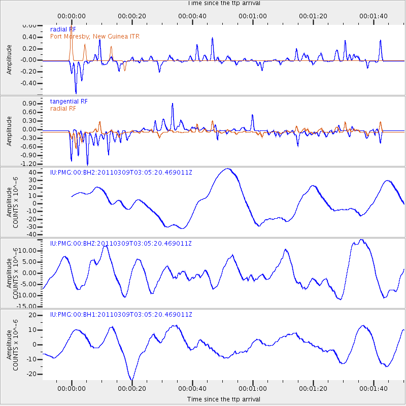
PMG Port Moresby, New Guinea - Earthquake Result Viewer
*The percent match for this event was below the threshold and hence no stack was calculated.
| Earthquake location: |
Near East Coast Of Honshu, Japan |
| Earthquake latitude/longitude: |
38.4/142.9 |
| Earthquake time(UTC): |
2011/03/09 (068) 02:57:16 GMT |
| Earthquake Depth: |
23 km |
| Earthquake Magnitude: |
5.7 MB |
| Earthquake Catalog/Contributor: |
NEIC PDE/NEIC PDE-M |
|
| Network: |
IU Global Seismograph Network (GSN - IRIS/USGS) |
| Station: |
PMG Port Moresby, New Guinea |
| Lat/Lon: |
9.40 S/147.16 E |
| Elevation: |
90 m |
|
| Distance: |
47.7 deg |
| Az: |
174.325 deg |
| Baz: |
355.481 deg |
| Ray Param: |
$rayparam |
*The percent match for this event was below the threshold and hence was not used in the summary stack. |
|
| Radial Match: |
54.893383 % |
| Radial Bump: |
314 |
| Transverse Match: |
55.634605 % |
| Transverse Bump: |
316 |
| SOD ConfigId: |
558545 |
| Insert Time: |
2013-09-18 10:26:54.036 +0000 |
| GWidth: |
2.5 |
| Max Bumps: |
400 |
| Tol: |
0.001 |
|
Signal To Noise
| Channel | StoN | STA | LTA |
| IU:PMG:00:BHZ:20110309T03:05:20.469011Z | 0.6491412 | 4.578096E-6 | 7.052543E-6 |
| IU:PMG:00:BH1:20110309T03:05:20.469011Z | 1.1048712 | 8.432572E-6 | 7.632177E-6 |
| IU:PMG:00:BH2:20110309T03:05:20.469011Z | 4.177686 | 3.4119435E-5 | 8.167065E-6 |
| Arrivals |
| Ps | |
| PpPs | |
| PsPs/PpSs | |


