You are here: Home > Network List > II - Global Seismograph Network (GSN - IRIS/IDA) Stations List
> Station WRAB Tennant Creek, NT, Australia > Earthquake Result Viewer
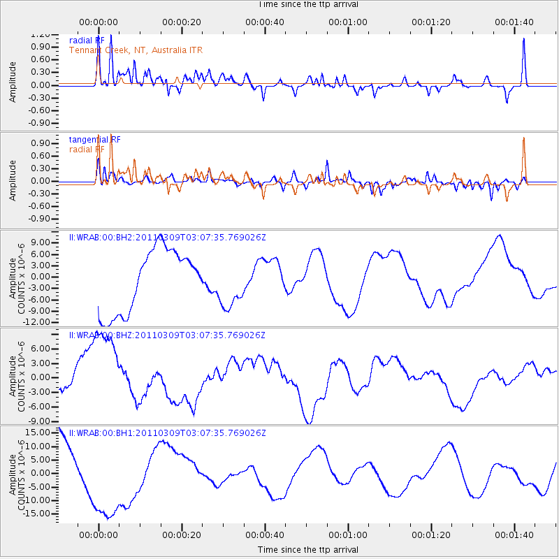
WRAB Tennant Creek, NT, Australia - Earthquake Result Viewer
*The percent match for this event was below the threshold and hence no stack was calculated.
| Earthquake location: |
Off East Coast Of Honshu, Japan |
| Earthquake latitude/longitude: |
38.2/143.1 |
| Earthquake time(UTC): |
2011/03/09 (068) 02:58:14 GMT |
| Earthquake Depth: |
35 km |
| Earthquake Magnitude: |
5.7 MB |
| Earthquake Catalog/Contributor: |
NEIC PDE/NEIC PDE-M |
|
| Network: |
II Global Seismograph Network (GSN - IRIS/IDA) |
| Station: |
WRAB Tennant Creek, NT, Australia |
| Lat/Lon: |
19.93 S/134.36 E |
| Elevation: |
366 m |
|
| Distance: |
58.5 deg |
| Az: |
189.66 deg |
| Baz: |
8.073 deg |
| Ray Param: |
$rayparam |
*The percent match for this event was below the threshold and hence was not used in the summary stack. |
|
| Radial Match: |
78.21819 % |
| Radial Bump: |
400 |
| Transverse Match: |
72.29029 % |
| Transverse Bump: |
400 |
| SOD ConfigId: |
558545 |
| Insert Time: |
2013-09-18 10:27:37.844 +0000 |
| GWidth: |
2.5 |
| Max Bumps: |
400 |
| Tol: |
0.001 |
|
Signal To Noise
| Channel | StoN | STA | LTA |
| II:WRAB:00:BHZ:20110309T03:07:35.769026Z | 1.8782744 | 9.418542E-6 | 5.014465E-6 |
| II:WRAB:00:BH1:20110309T03:07:35.769026Z | 1.2327428 | 1.644326E-5 | 1.333876E-5 |
| II:WRAB:00:BH2:20110309T03:07:35.769026Z | 0.7741674 | 6.3680836E-6 | 8.225718E-6 |
| Arrivals |
| Ps | |
| PpPs | |
| PsPs/PpSs | |


