You are here: Home > Network List > II - Global Seismograph Network (GSN - IRIS/IDA) Stations List
> Station WRAB Tennant Creek, NT, Australia > Earthquake Result Viewer
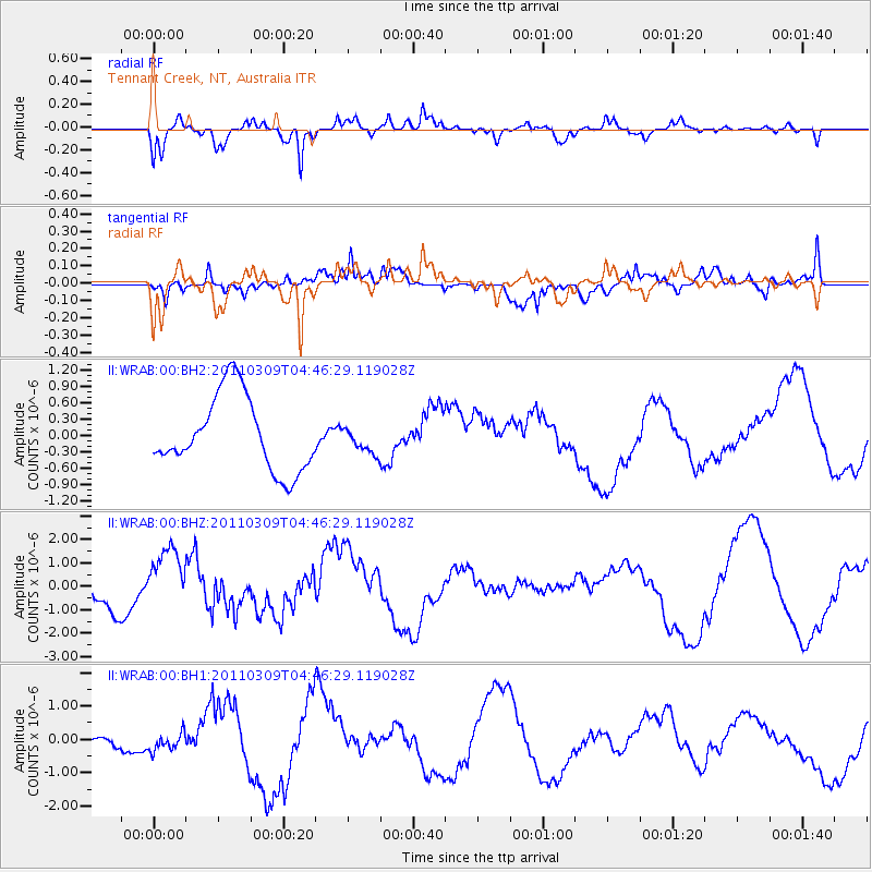
WRAB Tennant Creek, NT, Australia - Earthquake Result Viewer
*The percent match for this event was below the threshold and hence no stack was calculated.
| Earthquake location: |
Near East Coast Of Honshu, Japan |
| Earthquake latitude/longitude: |
38.7/143.0 |
| Earthquake time(UTC): |
2011/03/09 (068) 04:37:04 GMT |
| Earthquake Depth: |
38 km |
| Earthquake Magnitude: |
5.6 MB |
| Earthquake Catalog/Contributor: |
WHDF/NEIC |
|
| Network: |
II Global Seismograph Network (GSN - IRIS/IDA) |
| Station: |
WRAB Tennant Creek, NT, Australia |
| Lat/Lon: |
19.93 S/134.36 E |
| Elevation: |
366 m |
|
| Distance: |
58.8 deg |
| Az: |
189.496 deg |
| Baz: |
7.89 deg |
| Ray Param: |
$rayparam |
*The percent match for this event was below the threshold and hence was not used in the summary stack. |
|
| Radial Match: |
74.075554 % |
| Radial Bump: |
400 |
| Transverse Match: |
69.94687 % |
| Transverse Bump: |
400 |
| SOD ConfigId: |
558545 |
| Insert Time: |
2013-09-18 10:28:37.834 +0000 |
| GWidth: |
2.5 |
| Max Bumps: |
400 |
| Tol: |
0.001 |
|
Signal To Noise
| Channel | StoN | STA | LTA |
| II:WRAB:00:BHZ:20110309T04:46:29.119028Z | 2.6035793 | 1.3236206E-6 | 5.0838497E-7 |
| II:WRAB:00:BH1:20110309T04:46:29.119028Z | 1.1783094 | 2.7641204E-7 | 2.3458357E-7 |
| II:WRAB:00:BH2:20110309T04:46:29.119028Z | 0.35034472 | 2.3912798E-7 | 6.825506E-7 |
| Arrivals |
| Ps | |
| PpPs | |
| PsPs/PpSs | |


