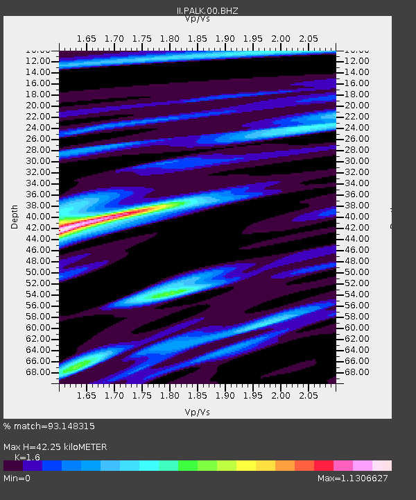
PALK Pallekele, Sri Lanka - Earthquake Result Viewer
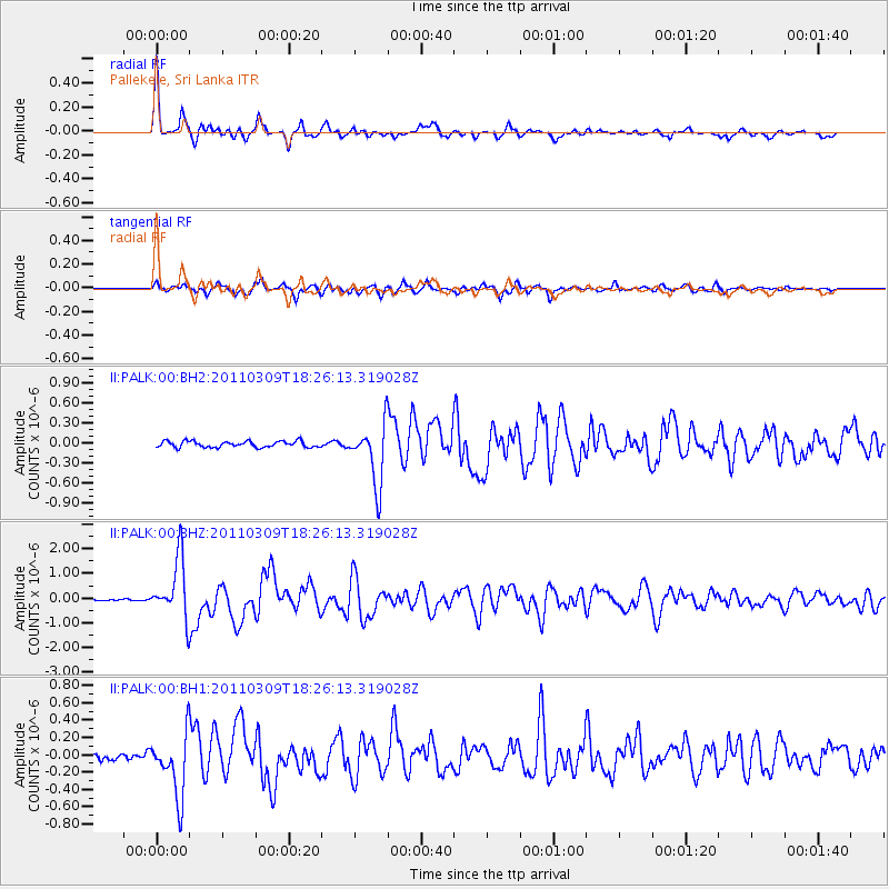
Earthquake location: Near East Coast Of Honshu, Japan
Earthquake latitude/longitude: 38.3/142.4
Earthquake time(UTC): 2011/03/09 (068) 18:16:16 GMT
Earthquake Depth: 22 km
Earthquake Magnitude: 6.0 MW, 5.8 MS, 5.8 MB, 6.0 MW
Earthquake Catalog/Contributor: NEIC PDE/NEIC PDE-M
Network: II Global Seismograph Network (GSN - IRIS/IDA)
Station: PALK Pallekele, Sri Lanka
Lat/Lon: 7.27 N/80.70 E
Elevation: 460 m
Distance: 63.4 deg
Az: 257.659 deg
Baz: 50.769 deg
Ray Param: 0.05955353
Estimated Moho Depth: 42.25 km
Estimated Crust Vp/Vs: 1.60
Assumed Crust Vp: 6.545 km/s
Estimated Crust Vs: 4.091 km/s
Estimated Crust Poisson's Ratio: 0.18
Radial Match: 93.148315 %
Radial Bump: 396
Transverse Match: 83.657555 %
Transverse Bump: 400
SOD ConfigId: 558545
Insert Time: 2013-09-18 10:29:38.515 +0000
GWidth: 2.5
Max Bumps: 400
Tol: 0.001

Signal To Noise

ChannelStoNSTALTA
II:PALK:00:BHZ:20110309T18:26:13.319028Z22.7070921.2018488E-65.2928343E-8
II:PALK:00:BH1:20110309T18:26:13.319028Z7.2991723.5967656E-74.9276352E-8
II:PALK:00:BH2:20110309T18:26:13.319028Z9.9400894.5278426E-74.5551328E-8
Arrivals
Ps4.1 SECOND
PpPs16 SECOND
PsPs/PpSs20 SECOND