You are here: Home > Network List > IU - Global Seismograph Network (GSN - IRIS/USGS) Stations List
> Station PMG Port Moresby, New Guinea > Earthquake Result Viewer
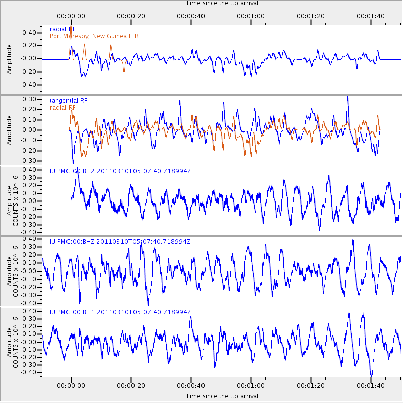
PMG Port Moresby, New Guinea - Earthquake Result Viewer
*The percent match for this event was below the threshold and hence no stack was calculated.
| Earthquake location: |
Myanmar-China Border Region |
| Earthquake latitude/longitude: |
24.7/98.0 |
| Earthquake time(UTC): |
2011/03/10 (069) 04:58:13 GMT |
| Earthquake Depth: |
10 km |
| Earthquake Magnitude: |
5.5 MW |
| Earthquake Catalog/Contributor: |
NEIC PDE/NEIC PDE-M |
|
| Network: |
IU Global Seismograph Network (GSN - IRIS/USGS) |
| Station: |
PMG Port Moresby, New Guinea |
| Lat/Lon: |
9.40 S/147.16 E |
| Elevation: |
90 m |
|
| Distance: |
58.8 deg |
| Az: |
119.103 deg |
| Baz: |
306.366 deg |
| Ray Param: |
$rayparam |
*The percent match for this event was below the threshold and hence was not used in the summary stack. |
|
| Radial Match: |
55.830864 % |
| Radial Bump: |
400 |
| Transverse Match: |
66.53797 % |
| Transverse Bump: |
400 |
| SOD ConfigId: |
558545 |
| Insert Time: |
2013-09-18 10:35:35.268 +0000 |
| GWidth: |
2.5 |
| Max Bumps: |
400 |
| Tol: |
0.001 |
|
Signal To Noise
| Channel | StoN | STA | LTA |
| IU:PMG:00:BHZ:20110310T05:07:40.718994Z | 1.3580288 | 1.4523613E-7 | 1.0694628E-7 |
| IU:PMG:00:BH1:20110310T05:07:40.718994Z | 0.5589111 | 9.293643E-8 | 1.6628124E-7 |
| IU:PMG:00:BH2:20110310T05:07:40.718994Z | 0.8369262 | 1.10323555E-7 | 1.3181993E-7 |
| Arrivals |
| Ps | |
| PpPs | |
| PsPs/PpSs | |


