You are here: Home > Network List > II - Global Seismograph Network (GSN - IRIS/IDA) Stations List
> Station ABPO Ambohimpanompo, Madagascar > Earthquake Result Viewer
ABPO Ambohimpanompo, Madagascar - Earthquake Result Viewer
| Earthquake location: |
Bali Sea |
| Earthquake latitude/longitude: |
-6.9/116.7 |
| Earthquake time(UTC): |
2011/03/10 (069) 17:08:36 GMT |
| Earthquake Depth: |
511 km |
| Earthquake Magnitude: |
6.6 MW, 6.2 MB, 6.5 MW |
| Earthquake Catalog/Contributor: |
NEIC PDE/NEIC PDE-M |
|
| Network: |
II Global Seismograph Network (GSN - IRIS/IDA) |
| Station: |
ABPO Ambohimpanompo, Madagascar |
| Lat/Lon: |
19.02 S/47.23 E |
| Elevation: |
1528 m |
|
| Distance: |
68.4 deg |
| Az: |
252.334 deg |
| Baz: |
89.987 deg |
| Ray Param: |
0.054564178 |
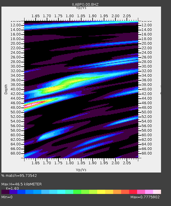
| Estimated Moho Depth: |
46.5 km |
| Estimated Crust Vp/Vs: |
1.63 |
| Assumed Crust Vp: |
6.642 km/s |
| Estimated Crust Vs: |
4.075 km/s |
| Estimated Crust Poisson's Ratio: |
0.20 |
|
| Radial Match: |
95.73542 % |
| Radial Bump: |
372 |
| Transverse Match: |
77.08153 % |
| Transverse Bump: |
400 |
| SOD ConfigId: |
558545 |
| Insert Time: |
2013-09-18 10:37:25.136 +0000 |
| GWidth: |
2.5 |
| Max Bumps: |
400 |
| Tol: |
0.001 |
|

Signal To Noise
| Channel | StoN | STA | LTA |
| II:ABPO:00:BHZ:20110310T17:18:16.368972Z | 33.637817 | 3.461337E-6 | 1.0290017E-7 |
| II:ABPO:00:BH1:20110310T17:18:16.368972Z | 3.5142305 | 2.2831377E-7 | 6.496835E-8 |
| II:ABPO:00:BH2:20110310T17:18:16.368972Z | 28.978611 | 1.6211586E-6 | 5.5943282E-8 |
| Arrivals |
| Ps | 4.6 SECOND |
| PpPs | 18 SECOND |
| PsPs/PpSs | 22 SECOND |


