You are here: Home > Network List > II - Global Seismograph Network (GSN - IRIS/IDA) Stations List
> Station PALK Pallekele, Sri Lanka > Earthquake Result Viewer
PALK Pallekele, Sri Lanka - Earthquake Result Viewer
| Earthquake location: |
Bali Sea |
| Earthquake latitude/longitude: |
-6.9/116.7 |
| Earthquake time(UTC): |
2011/03/10 (069) 17:08:36 GMT |
| Earthquake Depth: |
511 km |
| Earthquake Magnitude: |
6.6 MW, 6.2 MB, 6.5 MW |
| Earthquake Catalog/Contributor: |
NEIC PDE/NEIC PDE-M |
|
| Network: |
II Global Seismograph Network (GSN - IRIS/IDA) |
| Station: |
PALK Pallekele, Sri Lanka |
| Lat/Lon: |
7.27 N/80.70 E |
| Elevation: |
460 m |
|
| Distance: |
38.6 deg |
| Az: |
290.685 deg |
| Baz: |
110.555 deg |
| Ray Param: |
0.073016256 |
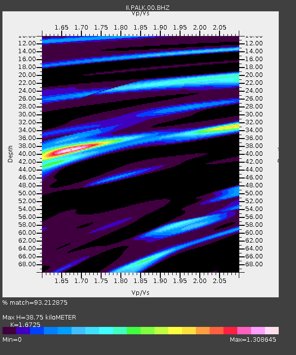
| Estimated Moho Depth: |
38.75 km |
| Estimated Crust Vp/Vs: |
1.67 |
| Assumed Crust Vp: |
6.545 km/s |
| Estimated Crust Vs: |
3.913 km/s |
| Estimated Crust Poisson's Ratio: |
0.22 |
|
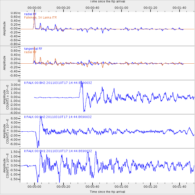
| Radial Match: |
93.212875 % |
| Radial Bump: |
361 |
| Transverse Match: |
81.07125 % |
| Transverse Bump: |
400 |
| SOD ConfigId: |
558545 |
| Insert Time: |
2013-09-18 10:37:35.023 +0000 |
| GWidth: |
2.5 |
| Max Bumps: |
400 |
| Tol: |
0.001 |
|
Signal To Noise
| Channel | StoN | STA | LTA |
| II:PALK:00:BHZ:20110310T17:14:44.869003Z | 75.122314 | 4.28143E-6 | 5.6992782E-8 |
| II:PALK:00:BH1:20110310T17:14:44.869003Z | 22.3206 | 9.277112E-7 | 4.1563002E-8 |
| II:PALK:00:BH2:20110310T17:14:44.869003Z | 54.16698 | 2.2647675E-6 | 4.1810853E-8 |
| Arrivals |
| Ps | 4.3 SECOND |
| PpPs | 15 SECOND |
| PsPs/PpSs | 19 SECOND |


