You are here: Home > Network List > II - Global Seismograph Network (GSN - IRIS/IDA) Stations List
> Station RAYN Ar Rayn, Saudi Arabia > Earthquake Result Viewer
RAYN Ar Rayn, Saudi Arabia - Earthquake Result Viewer
| Earthquake location: |
Bali Sea |
| Earthquake latitude/longitude: |
-6.9/116.7 |
| Earthquake time(UTC): |
2011/03/10 (069) 17:08:36 GMT |
| Earthquake Depth: |
511 km |
| Earthquake Magnitude: |
6.6 MW, 6.2 MB, 6.5 MW |
| Earthquake Catalog/Contributor: |
NEIC PDE/NEIC PDE-M |
|
| Network: |
II Global Seismograph Network (GSN - IRIS/IDA) |
| Station: |
RAYN Ar Rayn, Saudi Arabia |
| Lat/Lon: |
23.52 N/45.50 E |
| Elevation: |
631 m |
|
| Distance: |
75.7 deg |
| Az: |
296.284 deg |
| Baz: |
104.093 deg |
| Ray Param: |
0.04987748 |
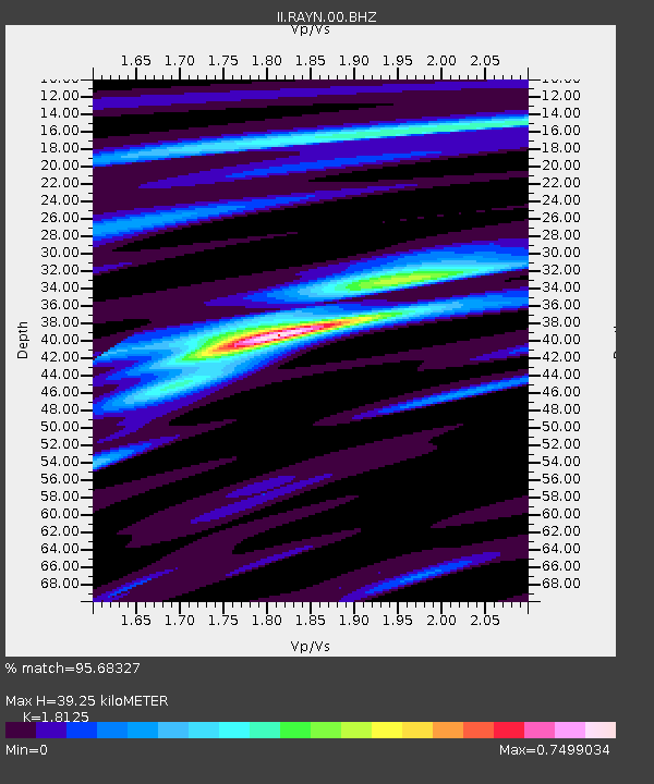
| Estimated Moho Depth: |
39.25 km |
| Estimated Crust Vp/Vs: |
1.81 |
| Assumed Crust Vp: |
6.498 km/s |
| Estimated Crust Vs: |
3.585 km/s |
| Estimated Crust Poisson's Ratio: |
0.28 |
|
| Radial Match: |
95.68327 % |
| Radial Bump: |
257 |
| Transverse Match: |
76.79451 % |
| Transverse Bump: |
400 |
| SOD ConfigId: |
558545 |
| Insert Time: |
2013-09-18 10:37:35.650 +0000 |
| GWidth: |
2.5 |
| Max Bumps: |
400 |
| Tol: |
0.001 |
|

Signal To Noise
| Channel | StoN | STA | LTA |
| II:RAYN:00:BHZ:20110310T17:18:58.669021Z | 49.3055 | 5.47231E-6 | 1.1098782E-7 |
| II:RAYN:00:BH1:20110310T17:18:58.669021Z | 28.422033 | 2.141043E-6 | 7.53304E-8 |
| II:RAYN:00:BH2:20110310T17:18:58.669021Z | 3.181079 | 2.2019265E-7 | 6.921948E-8 |
| Arrivals |
| Ps | 5.1 SECOND |
| PpPs | 16 SECOND |
| PsPs/PpSs | 22 SECOND |


