You are here: Home > Network List > IU - Global Seismograph Network (GSN - IRIS/USGS) Stations List
> Station GUMO Guam, Mariana Islands > Earthquake Result Viewer
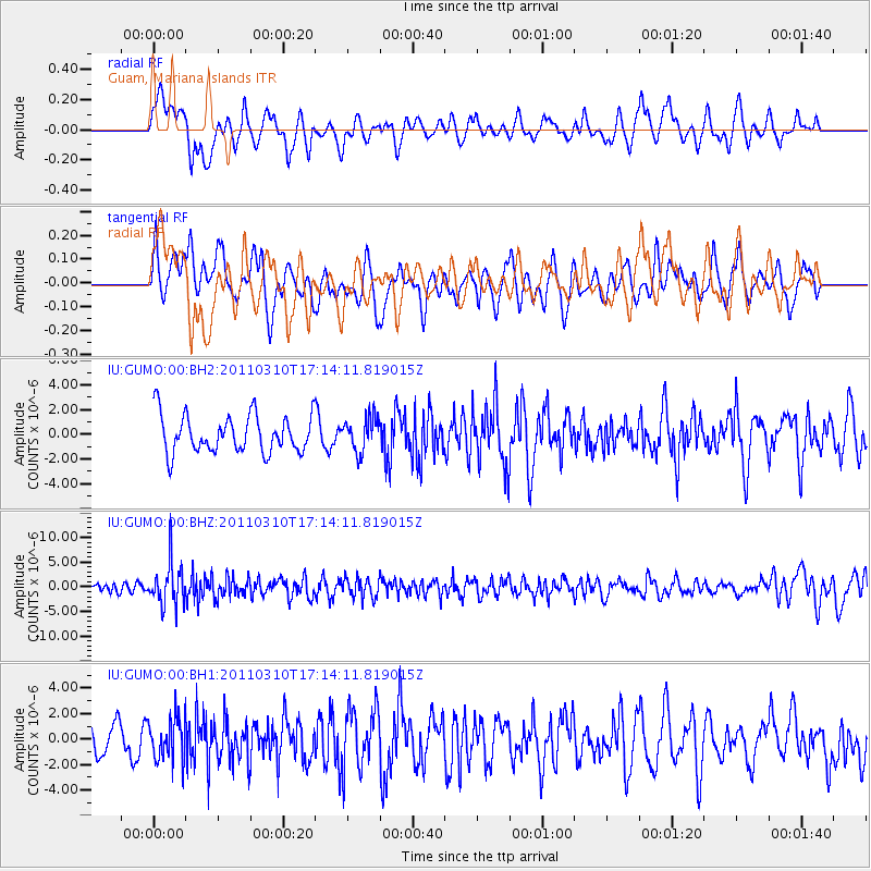
GUMO Guam, Mariana Islands - Earthquake Result Viewer
*The percent match for this event was below the threshold and hence no stack was calculated.
| Earthquake location: |
Bali Sea |
| Earthquake latitude/longitude: |
-6.9/116.7 |
| Earthquake time(UTC): |
2011/03/10 (069) 17:08:36 GMT |
| Earthquake Depth: |
511 km |
| Earthquake Magnitude: |
6.6 MW, 6.2 MB, 6.5 MW |
| Earthquake Catalog/Contributor: |
NEIC PDE/NEIC PDE-M |
|
| Network: |
IU Global Seismograph Network (GSN - IRIS/USGS) |
| Station: |
GUMO Guam, Mariana Islands |
| Lat/Lon: |
13.59 N/144.87 E |
| Elevation: |
170 m |
|
| Distance: |
34.6 deg |
| Az: |
53.962 deg |
| Baz: |
235.661 deg |
| Ray Param: |
$rayparam |
*The percent match for this event was below the threshold and hence was not used in the summary stack. |
|
| Radial Match: |
63.699078 % |
| Radial Bump: |
400 |
| Transverse Match: |
50.24405 % |
| Transverse Bump: |
400 |
| SOD ConfigId: |
558545 |
| Insert Time: |
2013-09-18 10:37:51.791 +0000 |
| GWidth: |
2.5 |
| Max Bumps: |
400 |
| Tol: |
0.001 |
|
Signal To Noise
| Channel | StoN | STA | LTA |
| IU:GUMO:00:BHZ:20110310T17:14:11.819015Z | 4.070754 | 4.3215973E-6 | 1.0616208E-6 |
| IU:GUMO:00:BH1:20110310T17:14:11.819015Z | 1.0800822 | 1.6288558E-6 | 1.5080851E-6 |
| IU:GUMO:00:BH2:20110310T17:14:11.819015Z | 0.8969218 | 1.363359E-6 | 1.5200422E-6 |
| Arrivals |
| Ps | |
| PpPs | |
| PsPs/PpSs | |


