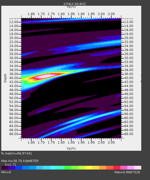
PALK Pallekele, Sri Lanka - Earthquake Result Viewer
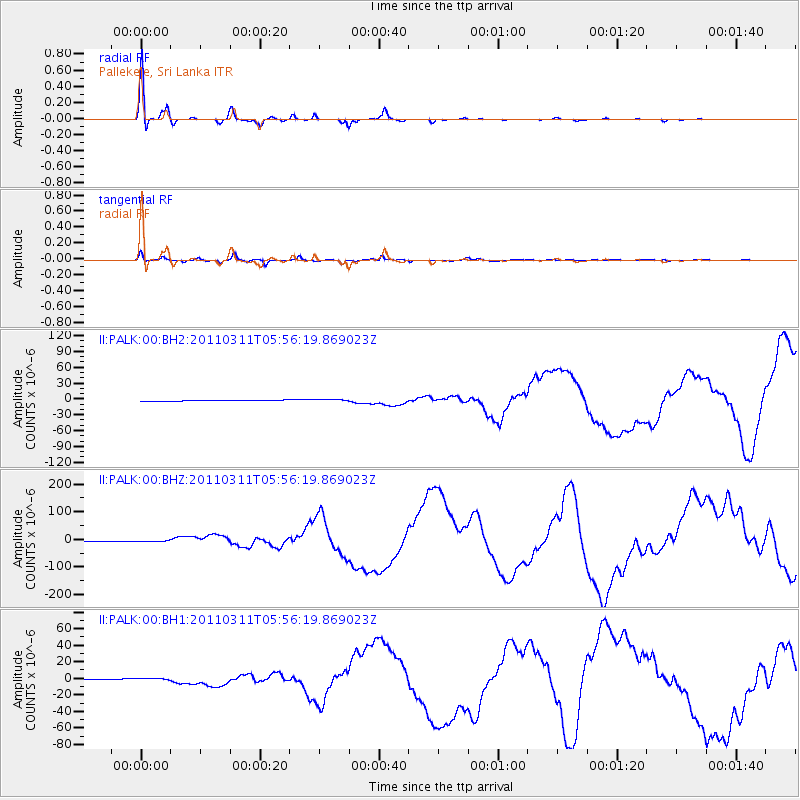
Earthquake location: Near East Coast Of Honshu, Japan
Earthquake latitude/longitude: 38.3/142.4
Earthquake time(UTC): 2011/03/11 (070) 05:46:24 GMT
Earthquake Depth: 29 km
Earthquake Magnitude: 9.0 MW, 7.2 MB, 8.3 MS, 9.0 MW
Earthquake Catalog/Contributor: NEIC PDE/NEIC PDE-M
Network: II Global Seismograph Network (GSN - IRIS/IDA)
Station: PALK Pallekele, Sri Lanka
Lat/Lon: 7.27 N/80.70 E
Elevation: 460 m
Distance: 63.4 deg
Az: 257.625 deg
Baz: 50.778 deg
Ray Param: 0.0595691
Estimated Moho Depth: 38.75 km
Estimated Crust Vp/Vs: 1.71
Assumed Crust Vp: 6.545 km/s
Estimated Crust Vs: 3.828 km/s
Estimated Crust Poisson's Ratio: 0.24
Radial Match: 98.97441 %
Radial Bump: 201
Transverse Match: 92.24154 %
Transverse Bump: 400
SOD ConfigId: 558545
Insert Time: 2013-09-18 10:40:11.153 +0000
GWidth: 2.5
Max Bumps: 400
Tol: 0.001

Signal To Noise

ChannelStoNSTALTA
II:PALK:00:BHZ:20110311T05:56:19.869023Z2.52097583.6854904E-61.4619301E-6
II:PALK:00:BH1:20110311T05:56:19.869023Z2.40800761.7281079E-67.176505E-7
II:PALK:00:BH2:20110311T05:56:19.869023Z2.5684031.9878144E-67.739496E-7
Arrivals
Ps4.4 SECOND
PpPs15 SECOND
PsPs/PpSs20 SECOND