You are here: Home > Network List > CI - Caltech Regional Seismic Network Stations List
> Station SLA SLA, Trona, CA, USA > Earthquake Result Viewer
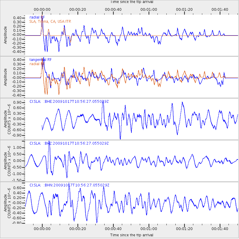
SLA SLA, Trona, CA, USA - Earthquake Result Viewer
*The percent match for this event was below the threshold and hence no stack was calculated.
| Earthquake location: |
Samoa Islands Region |
| Earthquake latitude/longitude: |
-16.4/-172.0 |
| Earthquake time(UTC): |
2009/10/17 (290) 10:45:26 GMT |
| Earthquake Depth: |
10 km |
| Earthquake Magnitude: |
5.7 MB, 5.3 MS, 5.7 MW, 5.7 MW |
| Earthquake Catalog/Contributor: |
WHDF/NEIC |
|
| Network: |
CI Caltech Regional Seismic Network |
| Station: |
SLA SLA, Trona, CA, USA |
| Lat/Lon: |
35.89 N/117.28 W |
| Elevation: |
1174 m |
|
| Distance: |
73.3 deg |
| Az: |
43.775 deg |
| Baz: |
234.878 deg |
| Ray Param: |
$rayparam |
*The percent match for this event was below the threshold and hence was not used in the summary stack. |
|
| Radial Match: |
83.24886 % |
| Radial Bump: |
400 |
| Transverse Match: |
57.418697 % |
| Transverse Bump: |
400 |
| SOD ConfigId: |
2622 |
| Insert Time: |
2010-02-25 20:37:30.246 +0000 |
| GWidth: |
2.5 |
| Max Bumps: |
400 |
| Tol: |
0.001 |
|
Signal To Noise
| Channel | StoN | STA | LTA |
| CI:SLA: :BHZ:20091017T10:56:27.055029Z | 1.8249916 | 6.365155E-7 | 3.4877723E-7 |
| CI:SLA: :BHN:20091017T10:56:27.055029Z | 1.1868759 | 3.016452E-7 | 2.5415056E-7 |
| CI:SLA: :BHE:20091017T10:56:27.055029Z | 1.2645565 | 4.0384742E-7 | 3.1935892E-7 |
| Arrivals |
| Ps | |
| PpPs | |
| PsPs/PpSs | |


