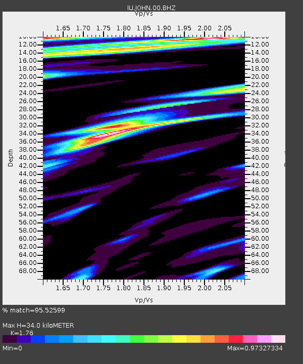
JOHN Johnston Island, USA - Earthquake Result Viewer

Earthquake location: Near East Coast Of Honshu, Japan
Earthquake latitude/longitude: 38.3/142.4
Earthquake time(UTC): 2011/03/11 (070) 05:46:24 GMT
Earthquake Depth: 29 km
Earthquake Magnitude: 9.0 MW, 7.2 MB, 8.3 MS, 9.0 MW
Earthquake Catalog/Contributor: NEIC PDE/NEIC PDE-M
Network: IU Global Seismograph Network (GSN - IRIS/USGS)
Station: JOHN Johnston Island, USA
Lat/Lon: 16.73 N/169.53 W
Elevation: 2.0 m
Distance: 47.1 deg
Az: 103.393 deg
Baz: 306.981 deg
Ray Param: 0.07012891
Estimated Moho Depth: 34.0 km
Estimated Crust Vp/Vs: 1.76
Assumed Crust Vp: 4.24 km/s
Estimated Crust Vs: 2.409 km/s
Estimated Crust Poisson's Ratio: 0.26
Radial Match: 95.52599 %
Radial Bump: 250
Transverse Match: 79.3686 %
Transverse Bump: 400
SOD ConfigId: 558545
Insert Time: 2013-09-18 10:40:46.121 +0000
GWidth: 2.5
Max Bumps: 400
Tol: 0.001

Signal To Noise

ChannelStoNSTALTA
IU:JOHN:00:BHZ:20110311T05:54:23.118993Z2.01550349.79056E-64.8576253E-6
IU:JOHN:00:BH1:20110311T05:54:23.118993Z1.32824816.391227E-64.811772E-6
IU:JOHN:00:BH2:20110311T05:54:23.118993Z2.07889277.750772E-63.7283176E-6
Arrivals
Ps6.3 SECOND
PpPs22 SECOND
PsPs/PpSs28 SECOND