You are here: Home > Network List > II - Global Seismograph Network (GSN - IRIS/IDA) Stations List
> Station WRAB Tennant Creek, NT, Australia > Earthquake Result Viewer
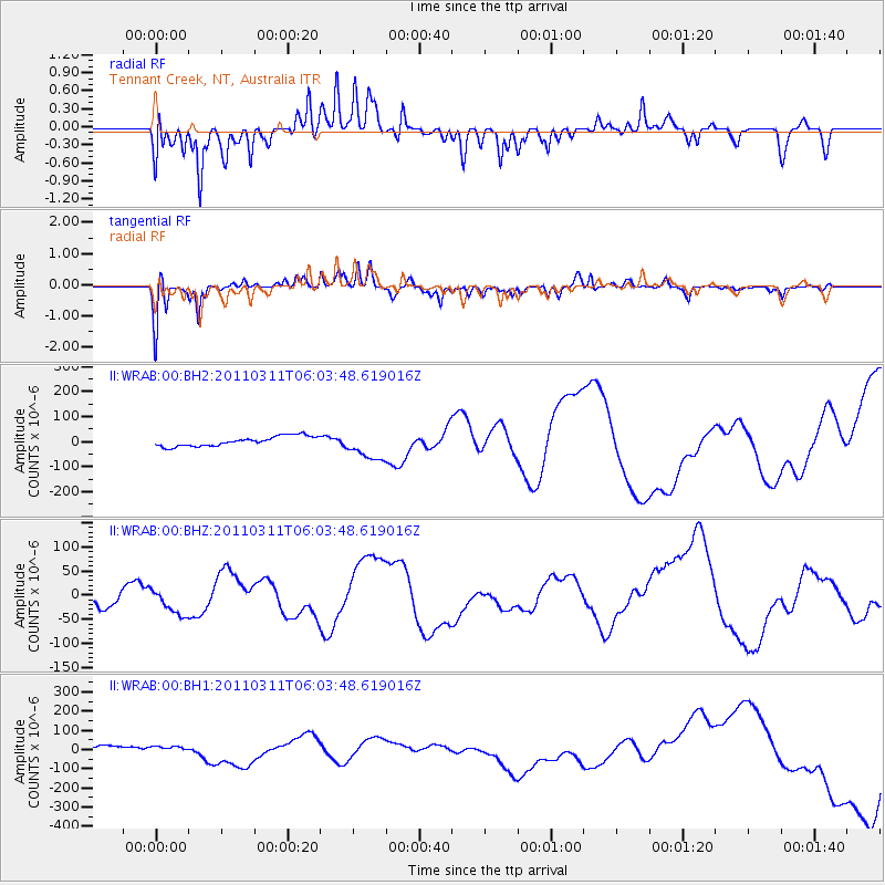
WRAB Tennant Creek, NT, Australia - Earthquake Result Viewer
*The percent match for this event was below the threshold and hence no stack was calculated.
| Earthquake location: |
Near East Coast Of Honshu, Japan |
| Earthquake latitude/longitude: |
37.7/141.2 |
| Earthquake time(UTC): |
2011/03/11 (070) 05:54:31 GMT |
| Earthquake Depth: |
32 km |
| Earthquake Magnitude: |
6.3 MB |
| Earthquake Catalog/Contributor: |
NEIC PDE/NEIC PDE-M |
|
| Network: |
II Global Seismograph Network (GSN - IRIS/IDA) |
| Station: |
WRAB Tennant Creek, NT, Australia |
| Lat/Lon: |
19.93 S/134.36 E |
| Elevation: |
366 m |
|
| Distance: |
57.7 deg |
| Az: |
187.6 deg |
| Baz: |
6.401 deg |
| Ray Param: |
$rayparam |
*The percent match for this event was below the threshold and hence was not used in the summary stack. |
|
| Radial Match: |
80.454216 % |
| Radial Bump: |
355 |
| Transverse Match: |
79.290344 % |
| Transverse Bump: |
345 |
| SOD ConfigId: |
558545 |
| Insert Time: |
2013-09-18 10:41:57.423 +0000 |
| GWidth: |
2.5 |
| Max Bumps: |
400 |
| Tol: |
0.001 |
|
Signal To Noise
| Channel | StoN | STA | LTA |
| II:WRAB:00:BHZ:20110311T06:03:48.619016Z | 1.7113407 | 2.9047416E-5 | 1.6973485E-5 |
| II:WRAB:00:BH1:20110311T06:03:48.619016Z | 1.4602327 | 2.7627148E-5 | 1.8919687E-5 |
| II:WRAB:00:BH2:20110311T06:03:48.619016Z | 2.9862719 | 5.8727506E-5 | 1.9665827E-5 |
| Arrivals |
| Ps | |
| PpPs | |
| PsPs/PpSs | |


