You are here: Home > Network List > II - Global Seismograph Network (GSN - IRIS/IDA) Stations List
> Station WRAB Tennant Creek, NT, Australia > Earthquake Result Viewer
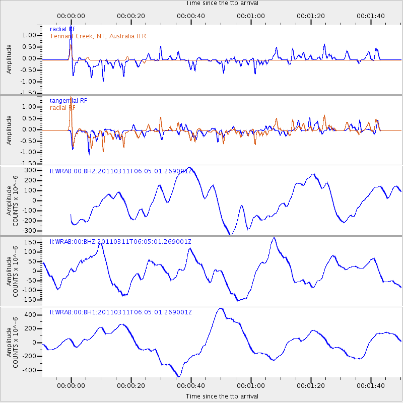
WRAB Tennant Creek, NT, Australia - Earthquake Result Viewer
*The percent match for this event was below the threshold and hence no stack was calculated.
| Earthquake location: |
Off East Coast Of Honshu, Japan |
| Earthquake latitude/longitude: |
37.4/143.4 |
| Earthquake time(UTC): |
2011/03/11 (070) 05:55:45 GMT |
| Earthquake Depth: |
35 km |
| Earthquake Magnitude: |
6.4 MB |
| Earthquake Catalog/Contributor: |
NEIC PDE/NEIC PDE-M |
|
| Network: |
II Global Seismograph Network (GSN - IRIS/IDA) |
| Station: |
WRAB Tennant Creek, NT, Australia |
| Lat/Lon: |
19.93 S/134.36 E |
| Elevation: |
366 m |
|
| Distance: |
57.6 deg |
| Az: |
190.027 deg |
| Baz: |
8.48 deg |
| Ray Param: |
$rayparam |
*The percent match for this event was below the threshold and hence was not used in the summary stack. |
|
| Radial Match: |
61.862072 % |
| Radial Bump: |
371 |
| Transverse Match: |
49.780052 % |
| Transverse Bump: |
353 |
| SOD ConfigId: |
558545 |
| Insert Time: |
2013-09-18 10:43:06.777 +0000 |
| GWidth: |
2.5 |
| Max Bumps: |
400 |
| Tol: |
0.001 |
|
Signal To Noise
| Channel | StoN | STA | LTA |
| II:WRAB:00:BHZ:20110311T06:05:01.269001Z | 1.3692209 | 5.4685293E-5 | 3.9938986E-5 |
| II:WRAB:00:BH1:20110311T06:05:01.269001Z | 1.4233202 | 6.8841706E-5 | 4.8366983E-5 |
| II:WRAB:00:BH2:20110311T06:05:01.269001Z | 1.7149636 | 1.7642954E-4 | 1.02876555E-4 |
| Arrivals |
| Ps | |
| PpPs | |
| PsPs/PpSs | |


