You are here: Home > Network List > IU - Global Seismograph Network (GSN - IRIS/USGS) Stations List
> Station JOHN Johnston Island, USA > Earthquake Result Viewer
JOHN Johnston Island, USA - Earthquake Result Viewer
| Earthquake location: |
Near East Coast Of Honshu, Japan |
| Earthquake latitude/longitude: |
37.1/141.8 |
| Earthquake time(UTC): |
2011/03/11 (070) 05:59:31 GMT |
| Earthquake Depth: |
8.4 km |
| Earthquake Magnitude: |
5.9 MB |
| Earthquake Catalog/Contributor: |
NEIC PDE/NEIC PDE-M |
|
| Network: |
IU Global Seismograph Network (GSN - IRIS/USGS) |
| Station: |
JOHN Johnston Island, USA |
| Lat/Lon: |
16.73 N/169.53 W |
| Elevation: |
2.0 m |
|
| Distance: |
47.3 deg |
| Az: |
101.805 deg |
| Baz: |
305.188 deg |
| Ray Param: |
0.070053466 |
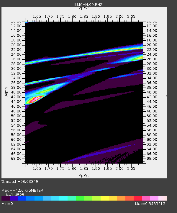
| Estimated Moho Depth: |
42.0 km |
| Estimated Crust Vp/Vs: |
1.65 |
| Assumed Crust Vp: |
4.24 km/s |
| Estimated Crust Vs: |
2.566 km/s |
| Estimated Crust Poisson's Ratio: |
0.21 |
|
| Radial Match: |
98.03349 % |
| Radial Bump: |
297 |
| Transverse Match: |
34.116528 % |
| Transverse Bump: |
400 |
| SOD ConfigId: |
558545 |
| Insert Time: |
2013-09-18 10:45:34.207 +0000 |
| GWidth: |
2.5 |
| Max Bumps: |
400 |
| Tol: |
0.001 |
|

Signal To Noise
| Channel | StoN | STA | LTA |
| IU:JOHN:00:BHZ:20110311T06:07:34.869001Z | 3.3139129 | 3.981424E-4 | 1.20142686E-4 |
| IU:JOHN:00:BH1:20110311T06:07:34.869001Z | 0.66247106 | 1.7372888E-4 | 2.6224373E-4 |
| IU:JOHN:00:BH2:20110311T06:07:34.869001Z | 1.4364458 | 2.7686232E-4 | 1.9274122E-4 |
| Arrivals |
| Ps | 6.6 SECOND |
| PpPs | 26 SECOND |
| PsPs/PpSs | 32 SECOND |


