You are here: Home > Network List > IU - Global Seismograph Network (GSN - IRIS/USGS) Stations List
> Station PMG Port Moresby, New Guinea > Earthquake Result Viewer
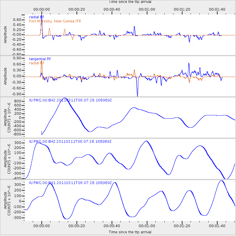
PMG Port Moresby, New Guinea - Earthquake Result Viewer
*The percent match for this event was below the threshold and hence no stack was calculated.
| Earthquake location: |
Near East Coast Of Honshu, Japan |
| Earthquake latitude/longitude: |
37.1/141.8 |
| Earthquake time(UTC): |
2011/03/11 (070) 05:59:31 GMT |
| Earthquake Depth: |
8.4 km |
| Earthquake Magnitude: |
5.9 MB |
| Earthquake Catalog/Contributor: |
NEIC PDE/NEIC PDE-M |
|
| Network: |
IU Global Seismograph Network (GSN - IRIS/USGS) |
| Station: |
PMG Port Moresby, New Guinea |
| Lat/Lon: |
9.40 S/147.16 E |
| Elevation: |
90 m |
|
| Distance: |
46.5 deg |
| Az: |
172.648 deg |
| Baz: |
354.045 deg |
| Ray Param: |
$rayparam |
*The percent match for this event was below the threshold and hence was not used in the summary stack. |
|
| Radial Match: |
61.810448 % |
| Radial Bump: |
320 |
| Transverse Match: |
76.26636 % |
| Transverse Bump: |
351 |
| SOD ConfigId: |
558545 |
| Insert Time: |
2013-09-18 10:45:39.772 +0000 |
| GWidth: |
2.5 |
| Max Bumps: |
400 |
| Tol: |
0.001 |
|
Signal To Noise
| Channel | StoN | STA | LTA |
| IU:PMG:00:BHZ:20110311T06:07:28.168989Z | 1.5516618 | 2.9403187E-4 | 1.894948E-4 |
| IU:PMG:00:BH1:20110311T06:07:28.168989Z | 4.4414377 | 2.847374E-4 | 6.410929E-5 |
| IU:PMG:00:BH2:20110311T06:07:28.168989Z | 1.3189282 | 6.7911664E-4 | 5.1490037E-4 |
| Arrivals |
| Ps | |
| PpPs | |
| PsPs/PpSs | |


