FRB IQALUIT, N.W.T. - Earthquake Result Viewer
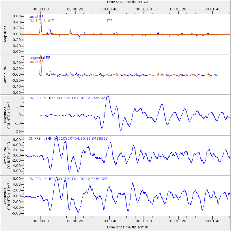
Earthquake location: Near Coast Of Jalisco, Mexico
Earthquake latitude/longitude: 18.8/-104.4
Earthquake time(UTC): 2001/05/20 (140) 04:21:43 GMT
Earthquake Depth: 33 km
Earthquake Magnitude: 5.5 MB, 6.0 MS, 6.5 MD, 6.3 MW
Earthquake Catalog/Contributor: WHDF/NEIC
Network: CN Canadian National Seismograph Network
Station: FRB IQALUIT, N.W.T.
Lat/Lon: 63.75 N/68.55 W
Elevation: 18 m
Distance: 51.1 deg
Az: 19.586 deg
Baz: 225.56 deg
Ray Param: 0.067584746
Estimated Moho Depth: 39.5 km
Estimated Crust Vp/Vs: 1.88
Assumed Crust Vp: 6.419 km/s
Estimated Crust Vs: 3.419 km/s
Estimated Crust Poisson's Ratio: 0.30
Radial Match: 96.0155 %
Radial Bump: 211
Transverse Match: 82.80904 %
Transverse Bump: 400
SOD ConfigId: 4714
Insert Time: 2010-02-27 05:44:56.644 +0000
GWidth: 2.5
Max Bumps: 400
Tol: 0.001

Signal To Noise

ChannelStoNSTALTA
CN:FRB: :BHN:20010520T04:30:12.348992Z3.22199941192.76370.19247
CN:FRB: :BHE:20010520T04:30:12.348992Z2.63663631235.8085468.70645
CN:FRB: :BHZ:20010520T04:30:12.348992Z4.0077953145.805784.92163
Arrivals
Ps5.7 SECOND
PpPs17 SECOND
PsPs/PpSs22 SECOND