You are here: Home > Network List > XL12 - Hangay Dome, Mongolia Stations List
> Station HV17 HV17 > Earthquake Result Viewer
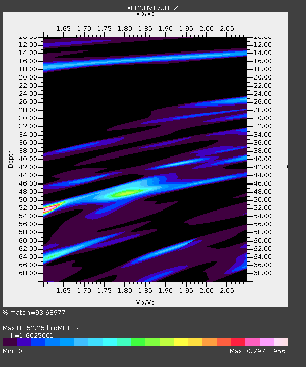
HV17 HV17 - Earthquake Result Viewer
| Earthquake location: |
Iceland |
| Earthquake latitude/longitude: |
64.7/-17.5 |
| Earthquake time(UTC): |
2014/09/01 (244) 11:41:10 GMT |
| Earthquake Depth: |
10 km |
| Earthquake Magnitude: |
5.5 MWW, 5.5 MWC |
| Earthquake Catalog/Contributor: |
NEIC PDE/NEIC COMCAT |
|
| Network: |
XL Hangay Dome, Mongolia |
| Station: |
HV17 HV17 |
| Lat/Lon: |
50.54 N/100.40 E |
| Elevation: |
1692 m |
|
| Distance: |
55.5 deg |
| Az: |
43.208 deg |
| Baz: |
332.527 deg |
| Ray Param: |
0.06476957 |
| Estimated Moho Depth: |
52.25 km |
| Estimated Crust Vp/Vs: |
1.60 |
| Assumed Crust Vp: |
6.419 km/s |
| Estimated Crust Vs: |
4.006 km/s |
| Estimated Crust Poisson's Ratio: |
0.18 |
|
| Radial Match: |
93.68977 % |
| Radial Bump: |
400 |
| Transverse Match: |
75.99867 % |
| Transverse Bump: |
400 |
| SOD ConfigId: |
3390531 |
| Insert Time: |
2019-04-13 18:38:17.405 +0000 |
| GWidth: |
2.5 |
| Max Bumps: |
400 |
| Tol: |
0.001 |
|

Signal To Noise
| Channel | StoN | STA | LTA |
| XL:HV17: :HHZ:20140901T11:50:14.818994Z | 11.38563 | 3.200264E-7 | 2.8107921E-8 |
| XL:HV17: :HHN:20140901T11:50:14.818994Z | 5.343124 | 1.2927325E-7 | 2.4194321E-8 |
| XL:HV17: :HHE:20140901T11:50:14.818994Z | 2.946958 | 7.8783316E-8 | 2.6733774E-8 |
| Arrivals |
| Ps | 5.2 SECOND |
| PpPs | 20 SECOND |
| PsPs/PpSs | 25 SECOND |


