You are here: Home > Network List > CN - Canadian National Seismograph Network Stations List
> Station FRB IQALUIT, N.W.T. > Earthquake Result Viewer
FRB IQALUIT, N.W.T. - Earthquake Result Viewer

| Earthquake location: |
South Of Panama |
| Earthquake latitude/longitude: |
7.9/-82.8 |
| Earthquake time(UTC): |
2002/07/31 (212) 00:16:44 GMT |
| Earthquake Depth: |
10 km |
| Earthquake Magnitude: |
6.0 MB, 6.4 MS, 6.5 MW, 6.4 MW |
| Earthquake Catalog/Contributor: |
WHDF/NEIC |
|
| Network: |
CN Canadian National Seismograph Network |
| Station: |
FRB IQALUIT, N.W.T. |
| Lat/Lon: |
63.75 N/68.55 W |
| Elevation: |
18 m |
|
| Distance: |
56.7 deg |
| Az: |
7.528 deg |
| Baz: |
196.967 deg |
| Ray Param: |
0.064002484 |
| Estimated Moho Depth: |
43.0 km |
| Estimated Crust Vp/Vs: |
1.71 |
| Assumed Crust Vp: |
6.419 km/s |
| Estimated Crust Vs: |
3.759 km/s |
| Estimated Crust Poisson's Ratio: |
0.24 |
|
| Radial Match: |
95.90979 % |
| Radial Bump: |
400 |
| Transverse Match: |
80.06256 % |
| Transverse Bump: |
400 |
| SOD ConfigId: |
20082 |
| Insert Time: |
2010-02-27 05:45:19.157 +0000 |
| GWidth: |
2.5 |
| Max Bumps: |
400 |
| Tol: |
0.001 |
|
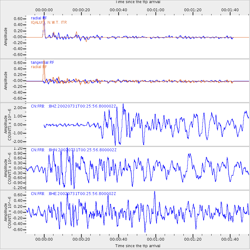
Signal To Noise
| Channel | StoN | STA | LTA |
| CN:FRB: :BHN:20020731T00:25:56.800002Z | 5.409584 | 3.9777728E-7 | 7.353195E-8 |
| CN:FRB: :BHE:20020731T00:25:56.800002Z | 1.6858557 | 1.5447927E-7 | 9.163255E-8 |
| CN:FRB: :BHZ:20020731T00:25:56.800002Z | 7.372215 | 7.5708743E-7 | 1.02694706E-7 |
| Arrivals |
| Ps | 5.0 SECOND |
| PpPs | 17 SECOND |
| PsPs/PpSs | 22 SECOND |


