You are here: Home > Network List > IU - Global Seismograph Network (GSN - IRIS/USGS) Stations List
> Station PMG Port Moresby, New Guinea > Earthquake Result Viewer
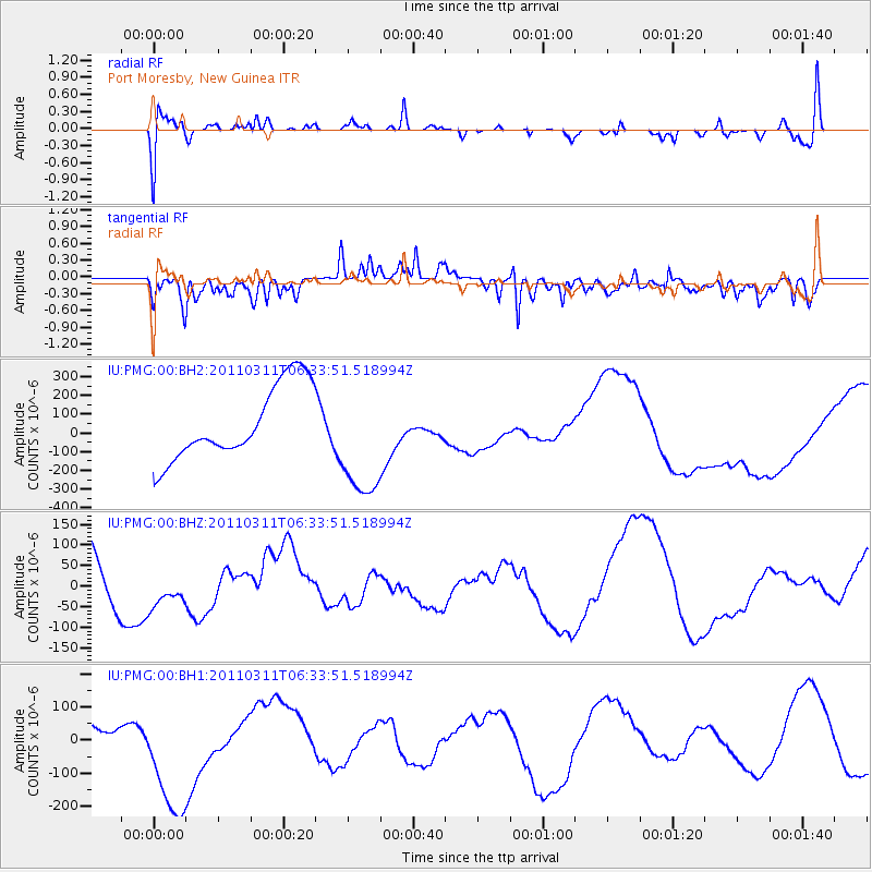
PMG Port Moresby, New Guinea - Earthquake Result Viewer
*The percent match for this event was below the threshold and hence no stack was calculated.
| Earthquake location: |
Off East Coast Of Honshu, Japan |
| Earthquake latitude/longitude: |
38.1/144.6 |
| Earthquake time(UTC): |
2011/03/11 (070) 06:25:50 GMT |
| Earthquake Depth: |
19 km |
| Earthquake Magnitude: |
7.6 MW, 7.1 MB, 7.7 MW |
| Earthquake Catalog/Contributor: |
NEIC PDE/NEIC PDE-M |
|
| Network: |
IU Global Seismograph Network (GSN - IRIS/USGS) |
| Station: |
PMG Port Moresby, New Guinea |
| Lat/Lon: |
9.40 S/147.16 E |
| Elevation: |
90 m |
|
| Distance: |
47.3 deg |
| Az: |
176.547 deg |
| Baz: |
357.239 deg |
| Ray Param: |
$rayparam |
*The percent match for this event was below the threshold and hence was not used in the summary stack. |
|
| Radial Match: |
60.665184 % |
| Radial Bump: |
400 |
| Transverse Match: |
56.78613 % |
| Transverse Bump: |
400 |
| SOD ConfigId: |
558545 |
| Insert Time: |
2013-09-18 11:01:40.520 +0000 |
| GWidth: |
2.5 |
| Max Bumps: |
400 |
| Tol: |
0.001 |
|
Signal To Noise
| Channel | StoN | STA | LTA |
| IU:PMG:00:BHZ:20110311T06:33:51.518994Z | 0.6871497 | 5.6794346E-5 | 8.265208E-5 |
| IU:PMG:00:BH1:20110311T06:33:51.518994Z | 1.6502966 | 1.8092683E-4 | 1.09632914E-4 |
| IU:PMG:00:BH2:20110311T06:33:51.518994Z | 1.6318532 | 3.1939638E-4 | 1.9572616E-4 |
| Arrivals |
| Ps | |
| PpPs | |
| PsPs/PpSs | |


