You are here: Home > Network List > IU - Global Seismograph Network (GSN - IRIS/USGS) Stations List
> Station JOHN Johnston Island, USA > Earthquake Result Viewer
JOHN Johnston Island, USA - Earthquake Result Viewer
| Earthquake location: |
Off East Coast Of Honshu, Japan |
| Earthquake latitude/longitude: |
37.8/144.2 |
| Earthquake time(UTC): |
2011/03/11 (070) 06:29:15 GMT |
| Earthquake Depth: |
41 km |
| Earthquake Magnitude: |
6.1 MB |
| Earthquake Catalog/Contributor: |
NEIC PDE/NEIC PDE-M |
|
| Network: |
IU Global Seismograph Network (GSN - IRIS/USGS) |
| Station: |
JOHN Johnston Island, USA |
| Lat/Lon: |
16.73 N/169.53 W |
| Elevation: |
2.0 m |
|
| Distance: |
45.6 deg |
| Az: |
104.423 deg |
| Baz: |
306.82 deg |
| Ray Param: |
0.071070254 |
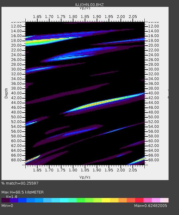
| Estimated Moho Depth: |
68.5 km |
| Estimated Crust Vp/Vs: |
1.60 |
| Assumed Crust Vp: |
4.24 km/s |
| Estimated Crust Vs: |
2.65 km/s |
| Estimated Crust Poisson's Ratio: |
0.18 |
|
| Radial Match: |
80.25597 % |
| Radial Bump: |
400 |
| Transverse Match: |
70.09653 % |
| Transverse Bump: |
343 |
| SOD ConfigId: |
558545 |
| Insert Time: |
2013-09-18 11:02:27.253 +0000 |
| GWidth: |
2.5 |
| Max Bumps: |
400 |
| Tol: |
0.001 |
|
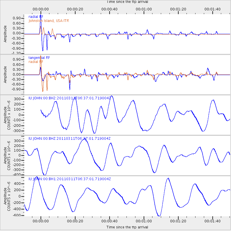
Signal To Noise
| Channel | StoN | STA | LTA |
| IU:JOHN:00:BHZ:20110311T06:37:01.719004Z | 2.7129154 | 3.1754776E-4 | 1.1705038E-4 |
| IU:JOHN:00:BH1:20110311T06:37:01.719004Z | 1.6545683 | 2.6981693E-4 | 1.6307391E-4 |
| IU:JOHN:00:BH2:20110311T06:37:01.719004Z | 1.1881573 | 2.2339812E-4 | 1.8802065E-4 |
| Arrivals |
| Ps | 10.0 SECOND |
| PpPs | 41 SECOND |
| PsPs/PpSs | 51 SECOND |


