You are here: Home > Network List > II - Global Seismograph Network (GSN - IRIS/IDA) Stations List
> Station WRAB Tennant Creek, NT, Australia > Earthquake Result Viewer
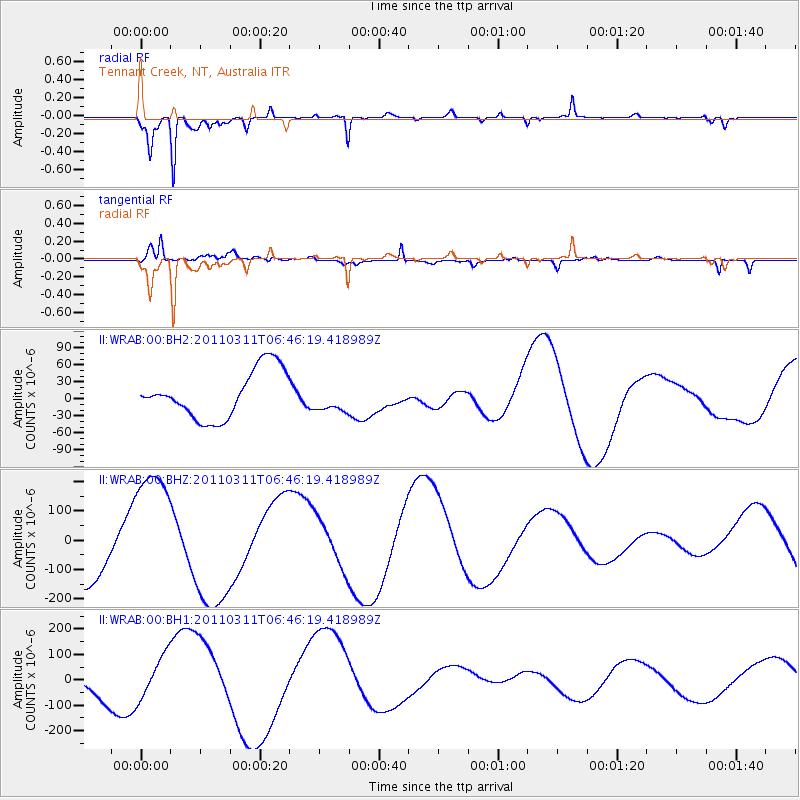
WRAB Tennant Creek, NT, Australia - Earthquake Result Viewer
*The percent match for this event was below the threshold and hence no stack was calculated.
| Earthquake location: |
Off East Coast Of Honshu, Japan |
| Earthquake latitude/longitude: |
37.5/142.4 |
| Earthquake time(UTC): |
2011/03/11 (070) 06:37:05 GMT |
| Earthquake Depth: |
52 km |
| Earthquake Magnitude: |
5.6 MB |
| Earthquake Catalog/Contributor: |
NEIC PDE/NEIC PDE-M |
|
| Network: |
II Global Seismograph Network (GSN - IRIS/IDA) |
| Station: |
WRAB Tennant Creek, NT, Australia |
| Lat/Lon: |
19.93 S/134.36 E |
| Elevation: |
366 m |
|
| Distance: |
57.6 deg |
| Az: |
188.971 deg |
| Baz: |
7.579 deg |
| Ray Param: |
$rayparam |
*The percent match for this event was below the threshold and hence was not used in the summary stack. |
|
| Radial Match: |
79.57345 % |
| Radial Bump: |
262 |
| Transverse Match: |
74.85219 % |
| Transverse Bump: |
400 |
| SOD ConfigId: |
558545 |
| Insert Time: |
2013-09-18 11:04:55.695 +0000 |
| GWidth: |
2.5 |
| Max Bumps: |
400 |
| Tol: |
0.001 |
|
Signal To Noise
| Channel | StoN | STA | LTA |
| II:WRAB:00:BHZ:20110311T06:46:19.418989Z | 2.3579957 | 2.25323E-4 | 9.555701E-5 |
| II:WRAB:00:BH1:20110311T06:46:19.418989Z | 1.2145636 | 8.6088075E-5 | 7.087984E-5 |
| II:WRAB:00:BH2:20110311T06:46:19.418989Z | 0.58303 | 2.4446295E-5 | 4.192974E-5 |
| Arrivals |
| Ps | |
| PpPs | |
| PsPs/PpSs | |


