You are here: Home > Network List > IU - Global Seismograph Network (GSN - IRIS/USGS) Stations List
> Station FUNA Funafuti, Tuvalu > Earthquake Result Viewer
FUNA Funafuti, Tuvalu - Earthquake Result Viewer
| Earthquake location: |
Off East Coast Of Honshu, Japan |
| Earthquake latitude/longitude: |
37.5/142.4 |
| Earthquake time(UTC): |
2011/03/11 (070) 06:37:05 GMT |
| Earthquake Depth: |
52 km |
| Earthquake Magnitude: |
5.6 MB |
| Earthquake Catalog/Contributor: |
NEIC PDE/NEIC PDE-M |
|
| Network: |
IU Global Seismograph Network (GSN - IRIS/USGS) |
| Station: |
FUNA Funafuti, Tuvalu |
| Lat/Lon: |
8.53 S/179.20 E |
| Elevation: |
20 m |
|
| Distance: |
57.2 deg |
| Az: |
135.22 deg |
| Baz: |
325.483 deg |
| Ray Param: |
0.063490905 |
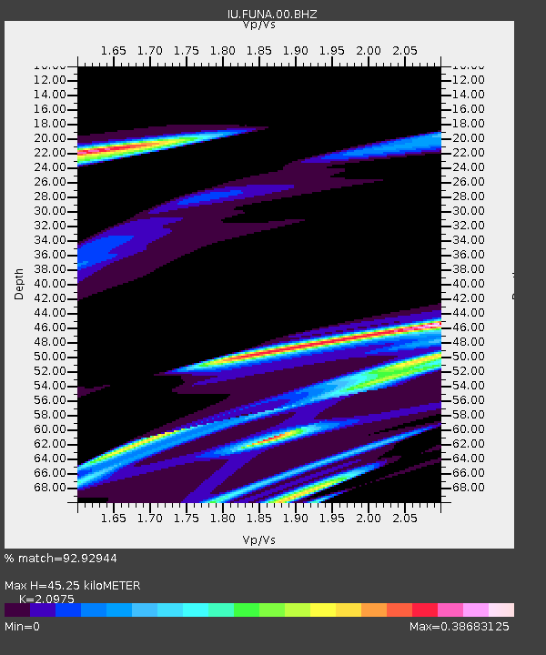
| Estimated Moho Depth: |
45.25 km |
| Estimated Crust Vp/Vs: |
2.10 |
| Assumed Crust Vp: |
4.24 km/s |
| Estimated Crust Vs: |
2.021 km/s |
| Estimated Crust Poisson's Ratio: |
0.35 |
|
| Radial Match: |
92.92944 % |
| Radial Bump: |
390 |
| Transverse Match: |
72.0489 % |
| Transverse Bump: |
375 |
| SOD ConfigId: |
558545 |
| Insert Time: |
2013-09-18 11:05:06.053 +0000 |
| GWidth: |
2.5 |
| Max Bumps: |
400 |
| Tol: |
0.001 |
|

Signal To Noise
| Channel | StoN | STA | LTA |
| IU:FUNA:00:BHZ:20110311T06:46:16.968977Z | 2.1095712 | 2.0635905E-4 | 9.7820375E-5 |
| IU:FUNA:00:BH1:20110311T06:46:16.968977Z | 2.1743655 | 2.8480034E-4 | 1.309809E-4 |
| IU:FUNA:00:BH2:20110311T06:46:16.968977Z | 3.1514082 | 2.4264E-4 | 7.6994154E-5 |
| Arrivals |
| Ps | 12 SECOND |
| PpPs | 32 SECOND |
| PsPs/PpSs | 44 SECOND |


