You are here: Home > Network List > II - Global Seismograph Network (GSN - IRIS/IDA) Stations List
> Station PFO Pinon Flat, California, USA > Earthquake Result Viewer
PFO Pinon Flat, California, USA - Earthquake Result Viewer

| Earthquake location: |
Near East Coast Of Honshu, Japan |
| Earthquake latitude/longitude: |
40.7/141.6 |
| Earthquake time(UTC): |
2011/03/11 (070) 06:49:57 GMT |
| Earthquake Depth: |
45 km |
| Earthquake Magnitude: |
5.8 MB |
| Earthquake Catalog/Contributor: |
WHDF/NEIC |
|
| Network: |
II Global Seismograph Network (GSN - IRIS/IDA) |
| Station: |
PFO Pinon Flat, California, USA |
| Lat/Lon: |
33.61 N/116.46 W |
| Elevation: |
1280 m |
|
| Distance: |
76.9 deg |
| Az: |
56.953 deg |
| Baz: |
310.179 deg |
| Ray Param: |
0.05059449 |
| Estimated Moho Depth: |
30.75 km |
| Estimated Crust Vp/Vs: |
2.08 |
| Assumed Crust Vp: |
6.264 km/s |
| Estimated Crust Vs: |
3.011 km/s |
| Estimated Crust Poisson's Ratio: |
0.35 |
|
| Radial Match: |
93.36684 % |
| Radial Bump: |
357 |
| Transverse Match: |
84.9706 % |
| Transverse Bump: |
400 |
| SOD ConfigId: |
558545 |
| Insert Time: |
2013-09-18 11:11:35.039 +0000 |
| GWidth: |
2.5 |
| Max Bumps: |
400 |
| Tol: |
0.001 |
|
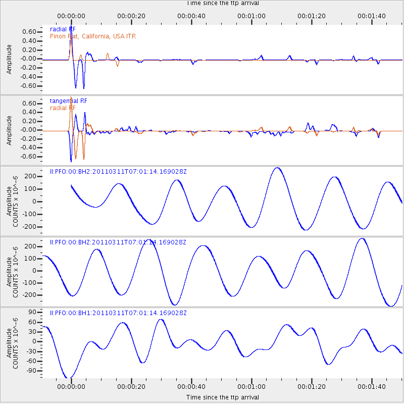
Signal To Noise
| Channel | StoN | STA | LTA |
| II:PFO:00:BHZ:20110311T07:01:14.169028Z | 2.371631 | 1.9278133E-4 | 8.12864E-5 |
| II:PFO:00:BH1:20110311T07:01:14.169028Z | 5.0188255 | 1.1460358E-4 | 2.283474E-5 |
| II:PFO:00:BH2:20110311T07:01:14.169028Z | 1.3498057 | 1.0549961E-4 | 7.8159115E-5 |
| Arrivals |
| Ps | 5.4 SECOND |
| PpPs | 15 SECOND |
| PsPs/PpSs | 20 SECOND |


