You are here: Home > Network List > CN - Canadian National Seismograph Network Stations List
> Station FRB IQALUIT, N.W.T. > Earthquake Result Viewer
FRB IQALUIT, N.W.T. - Earthquake Result Viewer
| Earthquake location: |
Central Mexico |
| Earthquake latitude/longitude: |
18.4/-97.4 |
| Earthquake time(UTC): |
1999/06/15 (166) 20:42:05 GMT |
| Earthquake Depth: |
70 km |
| Earthquake Magnitude: |
6.4 MB, 6.5 MS, 7.0 MW, 6.7 ME |
| Earthquake Catalog/Contributor: |
WHDF/NEIC |
|
| Network: |
CN Canadian National Seismograph Network |
| Station: |
FRB IQALUIT, N.W.T. |
| Lat/Lon: |
63.75 N/68.55 W |
| Elevation: |
18 m |
|
| Distance: |
49.4 deg |
| Az: |
16.434 deg |
| Baz: |
217.162 deg |
| Ray Param: |
0.068511486 |
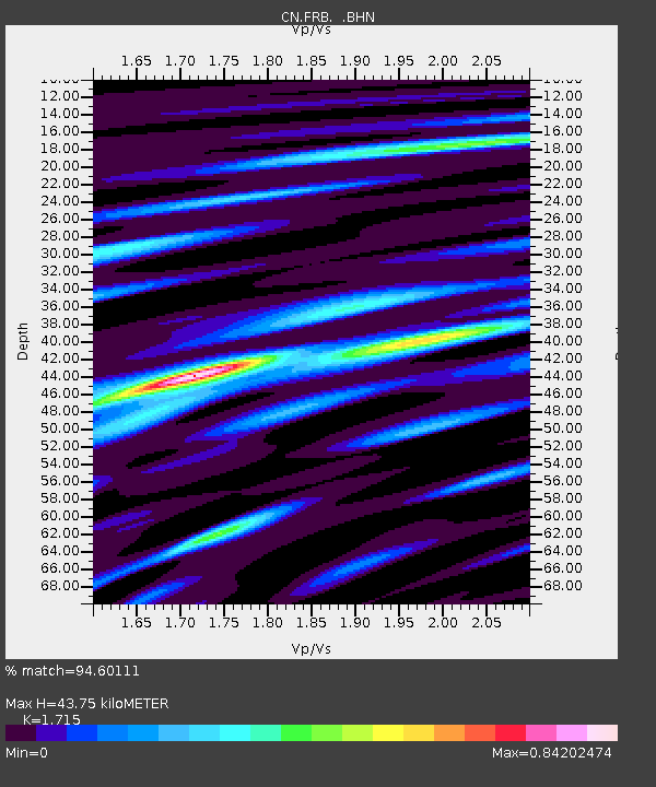
| Estimated Moho Depth: |
43.75 km |
| Estimated Crust Vp/Vs: |
1.72 |
| Assumed Crust Vp: |
6.419 km/s |
| Estimated Crust Vs: |
3.743 km/s |
| Estimated Crust Poisson's Ratio: |
0.24 |
|
| Radial Match: |
94.60111 % |
| Radial Bump: |
282 |
| Transverse Match: |
80.03267 % |
| Transverse Bump: |
400 |
| SOD ConfigId: |
4480 |
| Insert Time: |
2010-02-27 05:45:46.624 +0000 |
| GWidth: |
2.5 |
| Max Bumps: |
400 |
| Tol: |
0.001 |
|

Signal To Noise
| Channel | StoN | STA | LTA |
| CN:FRB: :BHN:19990615T20:50:18.199012Z | 38.1253 | 2.8868244E-6 | 7.5719385E-8 |
| CN:FRB: :BHE:19990615T20:50:18.199012Z | 20.118845 | 1.3849004E-6 | 6.883599E-8 |
| CN:FRB: :BHZ:19990615T20:50:18.199012Z | 15.300774 | 1.0327021E-6 | 6.749346E-8 |
| Arrivals |
| Ps | 5.2 SECOND |
| PpPs | 17 SECOND |
| PsPs/PpSs | 23 SECOND |


