You are here: Home > Network List > IU - Global Seismograph Network (GSN - IRIS/USGS) Stations List
> Station JOHN Johnston Island, USA > Earthquake Result Viewer
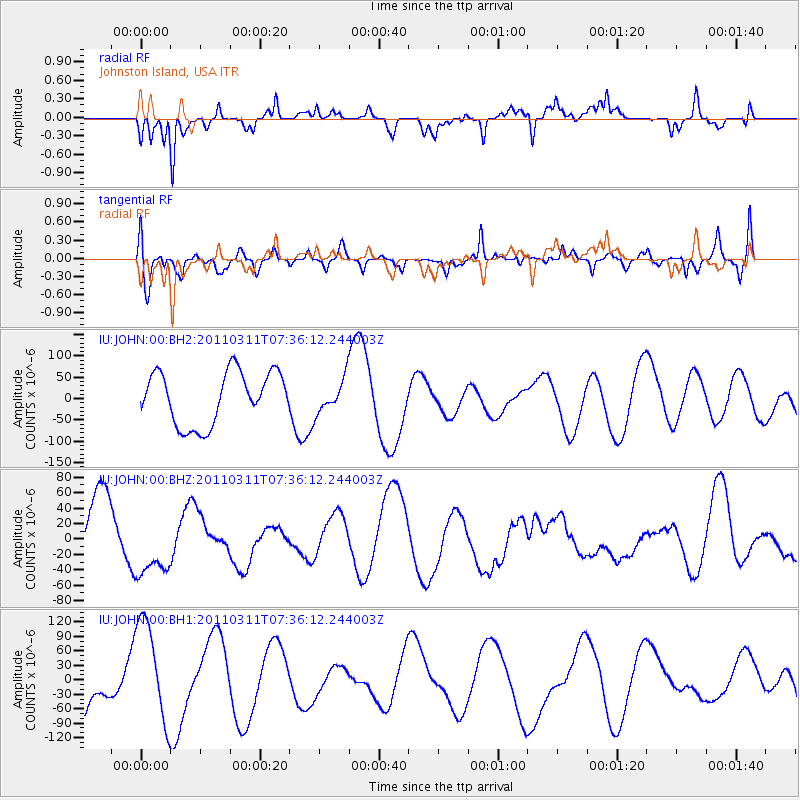
JOHN Johnston Island, USA - Earthquake Result Viewer
*The percent match for this event was below the threshold and hence no stack was calculated.
| Earthquake location: |
Near East Coast Of Honshu, Japan |
| Earthquake latitude/longitude: |
36.8/141.8 |
| Earthquake time(UTC): |
2011/03/11 (070) 07:28:12 GMT |
| Earthquake Depth: |
28 km |
| Earthquake Magnitude: |
6.1 MB |
| Earthquake Catalog/Contributor: |
WHDF/NEIC |
|
| Network: |
IU Global Seismograph Network (GSN - IRIS/USGS) |
| Station: |
JOHN Johnston Island, USA |
| Lat/Lon: |
16.73 N/169.53 W |
| Elevation: |
2.0 m |
|
| Distance: |
47.3 deg |
| Az: |
101.642 deg |
| Baz: |
304.895 deg |
| Ray Param: |
$rayparam |
*The percent match for this event was below the threshold and hence was not used in the summary stack. |
|
| Radial Match: |
51.02609 % |
| Radial Bump: |
317 |
| Transverse Match: |
43.019207 % |
| Transverse Bump: |
400 |
| SOD ConfigId: |
558545 |
| Insert Time: |
2013-09-18 11:30:22.035 +0000 |
| GWidth: |
2.5 |
| Max Bumps: |
400 |
| Tol: |
0.001 |
|
Signal To Noise
| Channel | StoN | STA | LTA |
| IU:JOHN:00:BHZ:20110311T07:36:12.244003Z | 1.613195 | 4.8217673E-5 | 2.9889552E-5 |
| IU:JOHN:00:BH1:20110311T07:36:12.244003Z | 2.9874725 | 1.09038854E-4 | 3.6498695E-5 |
| IU:JOHN:00:BH2:20110311T07:36:12.244003Z | 0.6315402 | 3.853373E-5 | 6.1015486E-5 |
| Arrivals |
| Ps | |
| PpPs | |
| PsPs/PpSs | |


