You are here: Home > Network List > IU - Global Seismograph Network (GSN - IRIS/USGS) Stations List
> Station POHA Pohakuloa, Hawaii, USA > Earthquake Result Viewer
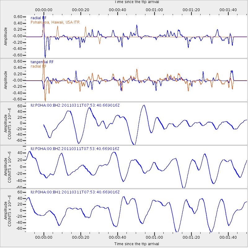
POHA Pohakuloa, Hawaii, USA - Earthquake Result Viewer
*The percent match for this event was below the threshold and hence no stack was calculated.
| Earthquake location: |
Near East Coast Of Honshu, Japan |
| Earthquake latitude/longitude: |
36.2/141.8 |
| Earthquake time(UTC): |
2011/03/11 (070) 07:44:27 GMT |
| Earthquake Depth: |
14 km |
| Earthquake Magnitude: |
5.8 MB |
| Earthquake Catalog/Contributor: |
WHDF/NEIC |
|
| Network: |
IU Global Seismograph Network (GSN - IRIS/USGS) |
| Station: |
POHA Pohakuloa, Hawaii, USA |
| Lat/Lon: |
19.76 N/155.53 W |
| Elevation: |
1990 m |
|
| Distance: |
56.8 deg |
| Az: |
88.806 deg |
| Baz: |
300.835 deg |
| Ray Param: |
$rayparam |
*The percent match for this event was below the threshold and hence was not used in the summary stack. |
|
| Radial Match: |
61.295174 % |
| Radial Bump: |
400 |
| Transverse Match: |
57.476162 % |
| Transverse Bump: |
275 |
| SOD ConfigId: |
558545 |
| Insert Time: |
2013-09-18 11:38:11.584 +0000 |
| GWidth: |
2.5 |
| Max Bumps: |
400 |
| Tol: |
0.001 |
|
Signal To Noise
| Channel | StoN | STA | LTA |
| IU:POHA:00:BHZ:20110311T07:53:40.669016Z | 0.8400157 | 2.2257193E-5 | 2.6496164E-5 |
| IU:POHA:00:BH1:20110311T07:53:40.669016Z | 1.229057 | 2.434191E-5 | 1.9805357E-5 |
| IU:POHA:00:BH2:20110311T07:53:40.669016Z | 0.25417194 | 8.781285E-6 | 3.45486E-5 |
| Arrivals |
| Ps | |
| PpPs | |
| PsPs/PpSs | |


