You are here: Home > Network List > GS - US Geological Survey Networks Stations List
> Station KAN10 Keim Farm > Earthquake Result Viewer
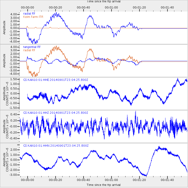
KAN10 Keim Farm - Earthquake Result Viewer
*The percent match for this event was below the threshold and hence no stack was calculated.
| Earthquake location: |
Near Coast Of Peru |
| Earthquake latitude/longitude: |
-15.0/-74.9 |
| Earthquake time(UTC): |
2014/09/01 (244) 22:55:20 GMT |
| Earthquake Depth: |
44 km |
| Earthquake Magnitude: |
5.2 MW |
| Earthquake Catalog/Contributor: |
ISC/ISC |
|
| Network: |
GS US Geological Survey Networks |
| Station: |
KAN10 Keim Farm |
| Lat/Lon: |
37.12 N/98.10 W |
| Elevation: |
417 m |
|
| Distance: |
56.3 deg |
| Az: |
337.782 deg |
| Baz: |
152.8 deg |
| Ray Param: |
$rayparam |
*The percent match for this event was below the threshold and hence was not used in the summary stack. |
|
| Radial Match: |
62.52593 % |
| Radial Bump: |
398 |
| Transverse Match: |
41.29035 % |
| Transverse Bump: |
381 |
| SOD ConfigId: |
3390531 |
| Insert Time: |
2019-04-13 18:43:40.727 +0000 |
| GWidth: |
2.5 |
| Max Bumps: |
400 |
| Tol: |
0.001 |
|
Signal To Noise
| Channel | StoN | STA | LTA |
| GS:KAN10:01:HHZ:20140901T23:04:25.800Z | 0.9123721 | 1.4601967E-7 | 1.6004398E-7 |
| GS:KAN10:01:HHN:20140901T23:04:25.800Z | 0.41023383 | 4.946884E-7 | 1.2058694E-6 |
| GS:KAN10:01:HHE:20140901T23:04:25.800Z | 2.66198 | 6.949815E-7 | 2.6107693E-7 |
| Arrivals |
| Ps | |
| PpPs | |
| PsPs/PpSs | |


