FRB IQALUIT, N.W.T. - Earthquake Result Viewer
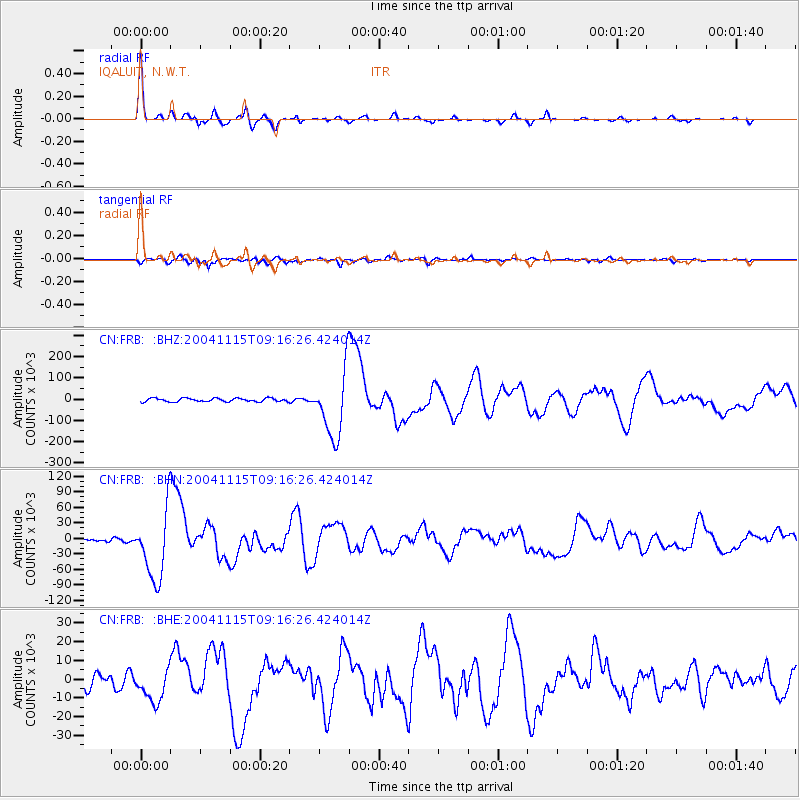
Earthquake location: Near West Coast Of Colombia
Earthquake latitude/longitude: 4.7/-77.5
Earthquake time(UTC): 2004/11/15 (320) 09:06:56 GMT
Earthquake Depth: 15 km
Earthquake Magnitude: 6.6 MB, 7.1 MS, 7.2 MW, 7.1 MW
Earthquake Catalog/Contributor: WHDF/NEIC
Network: CN Canadian National Seismograph Network
Station: FRB IQALUIT, N.W.T.
Lat/Lon: 63.75 N/68.55 W
Elevation: 18 m
Distance: 59.3 deg
Az: 4.622 deg
Baz: 190.403 deg
Ray Param: 0.062273968
Estimated Moho Depth: 44.0 km
Estimated Crust Vp/Vs: 1.71
Assumed Crust Vp: 6.419 km/s
Estimated Crust Vs: 3.765 km/s
Estimated Crust Poisson's Ratio: 0.24
Radial Match: 96.536095 %
Radial Bump: 296
Transverse Match: 90.21202 %
Transverse Bump: 400
SOD ConfigId: 2459
Insert Time: 2010-02-27 05:46:43.775 +0000
GWidth: 2.5
Max Bumps: 400
Tol: 0.001

Signal To Noise

ChannelStoNSTALTA
CN:FRB: :BHN:20041115T09:16:26.424014Z19.49683266883.1953430.4648
CN:FRB: :BHE:20041115T09:16:26.424014Z2.23687558864.1983962.759
CN:FRB: :BHZ:20041115T09:16:26.424014Z19.283298156854.488134.2144
Arrivals
Ps5.1 SECOND
PpPs18 SECOND
PsPs/PpSs23 SECOND