You are here: Home > Network List > CN - Canadian National Seismograph Network Stations List
> Station FRB IQALUIT, N.W.T. > Earthquake Result Viewer
FRB IQALUIT, N.W.T. - Earthquake Result Viewer
| Earthquake location: |
Near Coast Of Nicaragua |
| Earthquake latitude/longitude: |
11.4/-86.7 |
| Earthquake time(UTC): |
2004/10/09 (283) 21:26:53 GMT |
| Earthquake Depth: |
35 km |
| Earthquake Magnitude: |
6.0 MB, 7.0 MS, 6.9 MW, 6.8 MW |
| Earthquake Catalog/Contributor: |
WHDF/NEIC |
|
| Network: |
CN Canadian National Seismograph Network |
| Station: |
FRB IQALUIT, N.W.T. |
| Lat/Lon: |
63.75 N/68.55 W |
| Elevation: |
18 m |
|
| Distance: |
53.8 deg |
| Az: |
9.869 deg |
| Baz: |
202.201 deg |
| Ray Param: |
0.06579113 |
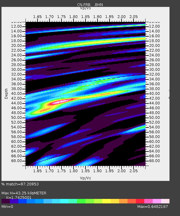
| Estimated Moho Depth: |
43.25 km |
| Estimated Crust Vp/Vs: |
1.74 |
| Assumed Crust Vp: |
6.419 km/s |
| Estimated Crust Vs: |
3.684 km/s |
| Estimated Crust Poisson's Ratio: |
0.25 |
|
| Radial Match: |
97.20953 % |
| Radial Bump: |
295 |
| Transverse Match: |
68.28479 % |
| Transverse Bump: |
400 |
| SOD ConfigId: |
2459 |
| Insert Time: |
2010-02-27 05:46:49.081 +0000 |
| GWidth: |
2.5 |
| Max Bumps: |
400 |
| Tol: |
0.001 |
|

Signal To Noise
| Channel | StoN | STA | LTA |
| CN:FRB: :BHN:20041009T21:35:42.20001Z | 20.105171 | 17321.492 | 861.5441 |
| CN:FRB: :BHE:20041009T21:35:42.20001Z | 4.172092 | 6915.0513 | 1657.4543 |
| CN:FRB: :BHZ:20041009T21:35:42.20001Z | 22.32259 | 37858.438 | 1695.9698 |
| Arrivals |
| Ps | 5.3 SECOND |
| PpPs | 17 SECOND |
| PsPs/PpSs | 23 SECOND |


