You are here: Home > Network List > IU - Global Seismograph Network (GSN - IRIS/USGS) Stations List
> Station PMG Port Moresby, New Guinea > Earthquake Result Viewer
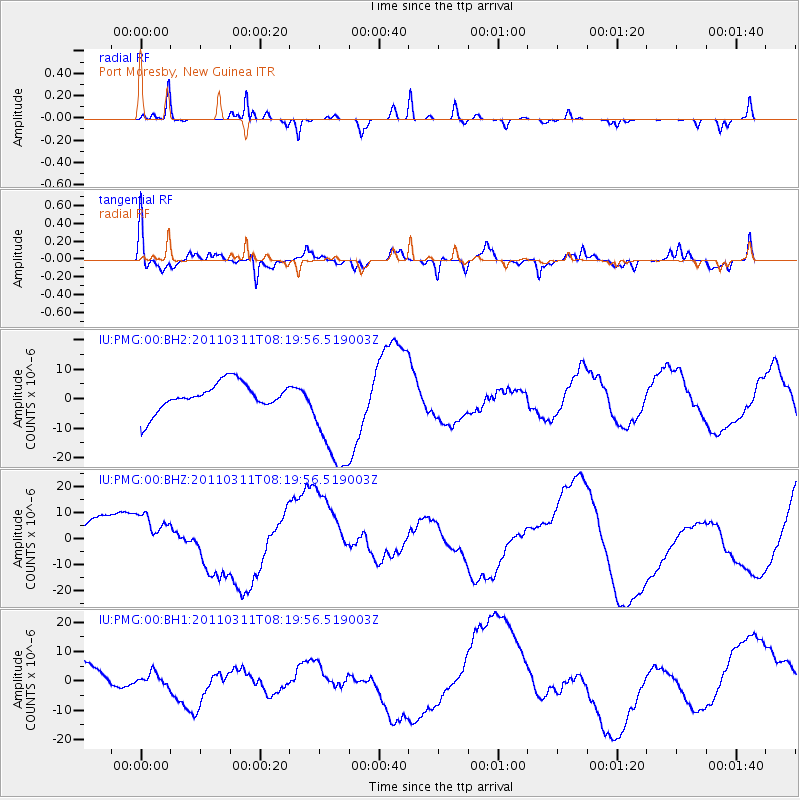
PMG Port Moresby, New Guinea - Earthquake Result Viewer
*The percent match for this event was below the threshold and hence no stack was calculated.
| Earthquake location: |
Near East Coast Of Honshu, Japan |
| Earthquake latitude/longitude: |
36.6/141.5 |
| Earthquake time(UTC): |
2011/03/11 (070) 08:12:07 GMT |
| Earthquake Depth: |
40 km |
| Earthquake Magnitude: |
6.2 MB |
| Earthquake Catalog/Contributor: |
WHDF/NEIC |
|
| Network: |
IU Global Seismograph Network (GSN - IRIS/USGS) |
| Station: |
PMG Port Moresby, New Guinea |
| Lat/Lon: |
9.40 S/147.16 E |
| Elevation: |
90 m |
|
| Distance: |
46.0 deg |
| Az: |
172.211 deg |
| Baz: |
353.652 deg |
| Ray Param: |
$rayparam |
*The percent match for this event was below the threshold and hence was not used in the summary stack. |
|
| Radial Match: |
64.603745 % |
| Radial Bump: |
206 |
| Transverse Match: |
52.760544 % |
| Transverse Bump: |
376 |
| SOD ConfigId: |
558545 |
| Insert Time: |
2013-09-18 11:46:26.368 +0000 |
| GWidth: |
2.5 |
| Max Bumps: |
400 |
| Tol: |
0.001 |
|
Signal To Noise
| Channel | StoN | STA | LTA |
| IU:PMG:00:BHZ:20110311T08:19:56.519003Z | 1.0207099 | 9.0838885E-6 | 8.899579E-6 |
| IU:PMG:00:BH1:20110311T08:19:56.519003Z | 0.2613772 | 2.0423656E-6 | 7.813864E-6 |
| IU:PMG:00:BH2:20110311T08:19:56.519003Z | 3.9655597 | 1.8777871E-5 | 4.7352387E-6 |
| Arrivals |
| Ps | |
| PpPs | |
| PsPs/PpSs | |


