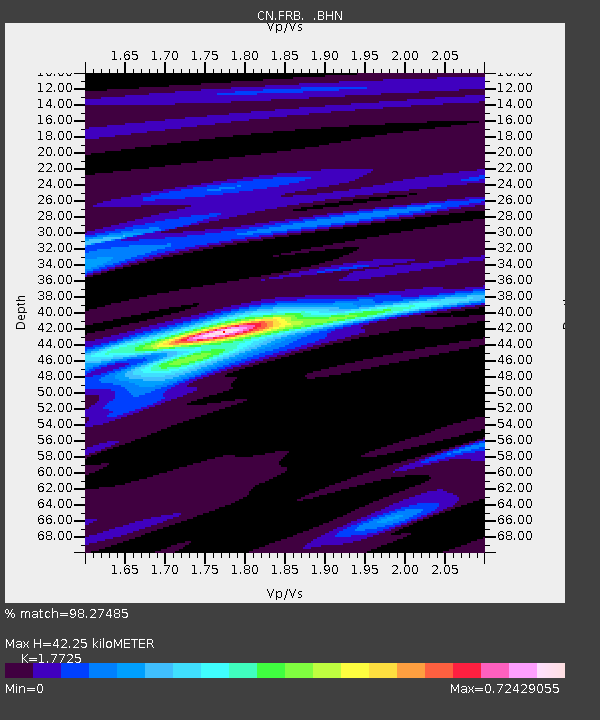
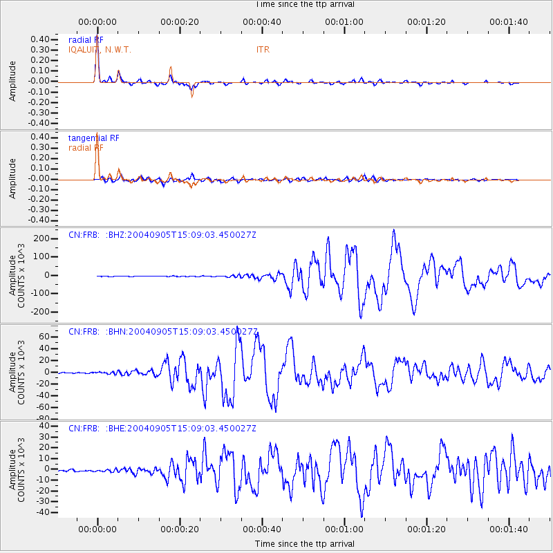
FRB IQALUIT, N.W.T. - Earthquake Result Viewer

Earthquake location: Near S. Coast Of Honshu, Japan
Earthquake latitude/longitude: 33.2/137.1
Earthquake time(UTC): 2004/09/05 (249) 14:57:18 GMT
Earthquake Depth: 10 km
Earthquake Magnitude: 6.2 MB, 7.1 MS, 7.4 MW, 7.4 MW
Earthquake Catalog/Contributor: WHDF/NEIC
Network: CN Canadian National Seismograph Network
Station: FRB IQALUIT, N.W.T.
Lat/Lon: 63.75 N/68.55 W
Elevation: 18 m
Distance: 81.3 deg
Az: 11.218 deg
Baz: 338.48 deg
Ray Param: 0.04769854
Estimated Moho Depth: 42.25 km
Estimated Crust Vp/Vs: 1.77
Assumed Crust Vp: 6.419 km/s
Estimated Crust Vs: 3.622 km/s
Estimated Crust Poisson's Ratio: 0.27
Radial Match: 98.27485 %
Radial Bump: 227
Transverse Match: 90.29591 %
Transverse Bump: 400
SOD ConfigId: 2459
Insert Time: 2010-02-27 05:46:54.212 +0000
GWidth: 2.5
Max Bumps: 400
Tol: 0.001

Signal To Noise

ChannelStoNSTALTA
CN:FRB: :BHN:20040905T15:09:03.450027Z1.38839331908.29321374.4615
CN:FRB: :BHE:20040905T15:09:03.450027Z1.02476611147.78641120.0471
CN:FRB: :BHZ:20040905T15:09:03.450027Z3.31735134975.88431499.9569
Arrivals
Ps5.2 SECOND
PpPs18 SECOND
PsPs/PpSs23 SECOND