You are here: Home > Network List > UW - Pacific Northwest Regional Seismic Network Stations List
> Station UMAT Pilot Rock, OR, USA > Earthquake Result Viewer
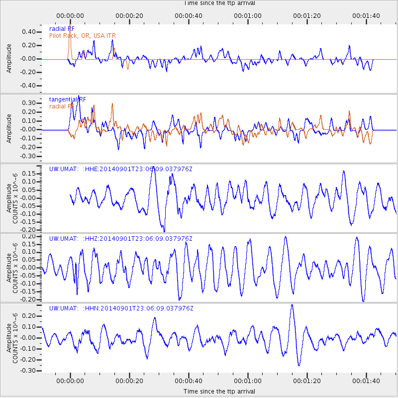
UMAT Pilot Rock, OR, USA - Earthquake Result Viewer
*The percent match for this event was below the threshold and hence no stack was calculated.
| Earthquake location: |
Near Coast Of Peru |
| Earthquake latitude/longitude: |
-15.0/-74.9 |
| Earthquake time(UTC): |
2014/09/01 (244) 22:55:20 GMT |
| Earthquake Depth: |
44 km |
| Earthquake Magnitude: |
5.2 MW |
| Earthquake Catalog/Contributor: |
ISC/ISC |
|
| Network: |
UW Pacific Northwest Regional Seismic Network |
| Station: |
UMAT Pilot Rock, OR, USA |
| Lat/Lon: |
45.29 N/118.96 W |
| Elevation: |
1318 m |
|
| Distance: |
72.1 deg |
| Az: |
328.954 deg |
| Baz: |
135.098 deg |
| Ray Param: |
$rayparam |
*The percent match for this event was below the threshold and hence was not used in the summary stack. |
|
| Radial Match: |
46.353462 % |
| Radial Bump: |
400 |
| Transverse Match: |
44.150246 % |
| Transverse Bump: |
400 |
| SOD ConfigId: |
3390531 |
| Insert Time: |
2019-04-13 18:47:53.952 +0000 |
| GWidth: |
2.5 |
| Max Bumps: |
400 |
| Tol: |
0.001 |
|
Signal To Noise
| Channel | StoN | STA | LTA |
| UW:UMAT: :HHZ:20140901T23:06:09.037976Z | 1.0188184 | 7.309122E-8 | 7.174117E-8 |
| UW:UMAT: :HHN:20140901T23:06:09.037976Z | 0.9188463 | 6.071866E-8 | 6.608141E-8 |
| UW:UMAT: :HHE:20140901T23:06:09.037976Z | 2.8781545 | 1.2151595E-7 | 4.2220094E-8 |
| Arrivals |
| Ps | |
| PpPs | |
| PsPs/PpSs | |


