You are here: Home > Network List > II - Global Seismograph Network (GSN - IRIS/IDA) Stations List
> Station WRAB Tennant Creek, NT, Australia > Earthquake Result Viewer
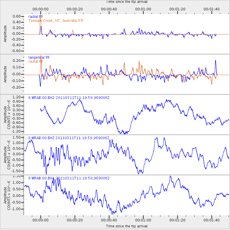
WRAB Tennant Creek, NT, Australia - Earthquake Result Viewer
*The percent match for this event was below the threshold and hence no stack was calculated.
| Earthquake location: |
Near East Coast Of Honshu, Japan |
| Earthquake latitude/longitude: |
35.5/141.8 |
| Earthquake time(UTC): |
2011/03/11 (070) 11:10:58 GMT |
| Earthquake Depth: |
35 km |
| Earthquake Magnitude: |
5.5 MB |
| Earthquake Catalog/Contributor: |
WHDF/NEIC |
|
| Network: |
II Global Seismograph Network (GSN - IRIS/IDA) |
| Station: |
WRAB Tennant Creek, NT, Australia |
| Lat/Lon: |
19.93 S/134.36 E |
| Elevation: |
366 m |
|
| Distance: |
55.6 deg |
| Az: |
188.537 deg |
| Baz: |
7.394 deg |
| Ray Param: |
$rayparam |
*The percent match for this event was below the threshold and hence was not used in the summary stack. |
|
| Radial Match: |
61.371056 % |
| Radial Bump: |
277 |
| Transverse Match: |
62.388657 % |
| Transverse Bump: |
295 |
| SOD ConfigId: |
558545 |
| Insert Time: |
2013-09-18 12:09:31.036 +0000 |
| GWidth: |
2.5 |
| Max Bumps: |
400 |
| Tol: |
0.001 |
|
Signal To Noise
| Channel | StoN | STA | LTA |
| II:WRAB:00:BHZ:20110311T11:19:59.969006Z | 1.0762647 | 1.2183745E-6 | 1.1320398E-6 |
| II:WRAB:00:BH1:20110311T11:19:59.969006Z | 0.62914795 | 6.167032E-7 | 9.802197E-7 |
| II:WRAB:00:BH2:20110311T11:19:59.969006Z | 0.9819992 | 5.323651E-7 | 5.4212376E-7 |
| Arrivals |
| Ps | |
| PpPs | |
| PsPs/PpSs | |


