You are here: Home > Network List > II - Global Seismograph Network (GSN - IRIS/IDA) Stations List
> Station PFO Pinon Flat, California, USA > Earthquake Result Viewer
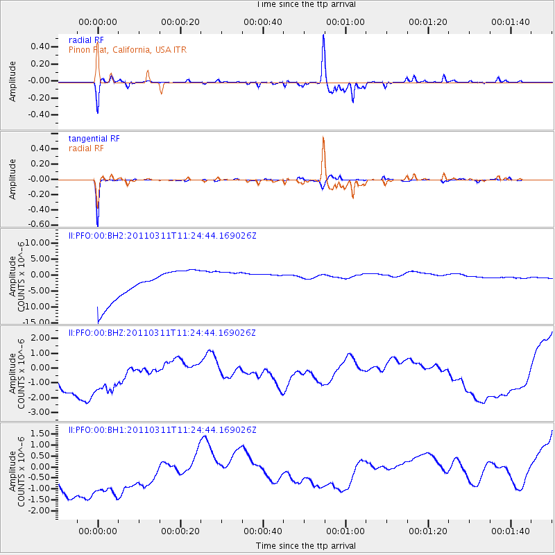
PFO Pinon Flat, California, USA - Earthquake Result Viewer
*The percent match for this event was below the threshold and hence no stack was calculated.
| Earthquake location: |
Near East Coast Of Honshu, Japan |
| Earthquake latitude/longitude: |
36.4/141.8 |
| Earthquake time(UTC): |
2011/03/11 (070) 11:13:12 GMT |
| Earthquake Depth: |
26 km |
| Earthquake Magnitude: |
5.5 MB |
| Earthquake Catalog/Contributor: |
WHDF/NEIC |
|
| Network: |
II Global Seismograph Network (GSN - IRIS/IDA) |
| Station: |
PFO Pinon Flat, California, USA |
| Lat/Lon: |
33.61 N/116.46 W |
| Elevation: |
1280 m |
|
| Distance: |
79.2 deg |
| Az: |
56.287 deg |
| Baz: |
306.449 deg |
| Ray Param: |
$rayparam |
*The percent match for this event was below the threshold and hence was not used in the summary stack. |
|
| Radial Match: |
63.71228 % |
| Radial Bump: |
170 |
| Transverse Match: |
85.226265 % |
| Transverse Bump: |
148 |
| SOD ConfigId: |
558545 |
| Insert Time: |
2013-09-18 12:10:49.192 +0000 |
| GWidth: |
2.5 |
| Max Bumps: |
400 |
| Tol: |
0.001 |
|
Signal To Noise
| Channel | StoN | STA | LTA |
| II:PFO:00:BHZ:20110311T11:24:44.169026Z | 1.1417964 | 4.937809E-6 | 4.324597E-6 |
| II:PFO:00:BH1:20110311T11:24:44.169026Z | 0.97278184 | 4.238552E-6 | 4.357145E-6 |
| II:PFO:00:BH2:20110311T11:24:44.169026Z | 0.83023804 | 3.7831155E-6 | 4.5566635E-6 |
| Arrivals |
| Ps | |
| PpPs | |
| PsPs/PpSs | |


