You are here: Home > Network List > IU - Global Seismograph Network (GSN - IRIS/USGS) Stations List
> Station FUNA Funafuti, Tuvalu > Earthquake Result Viewer
FUNA Funafuti, Tuvalu - Earthquake Result Viewer
| Earthquake location: |
Near East Coast Of Honshu, Japan |
| Earthquake latitude/longitude: |
36.4/141.8 |
| Earthquake time(UTC): |
2011/03/11 (070) 11:13:12 GMT |
| Earthquake Depth: |
26 km |
| Earthquake Magnitude: |
5.5 MB |
| Earthquake Catalog/Contributor: |
WHDF/NEIC |
|
| Network: |
IU Global Seismograph Network (GSN - IRIS/USGS) |
| Station: |
FUNA Funafuti, Tuvalu |
| Lat/Lon: |
8.53 S/179.20 E |
| Elevation: |
20 m |
|
| Distance: |
56.8 deg |
| Az: |
134.118 deg |
| Baz: |
324.145 deg |
| Ray Param: |
0.063838035 |
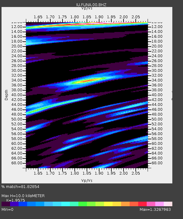
| Estimated Moho Depth: |
10.0 km |
| Estimated Crust Vp/Vs: |
1.96 |
| Assumed Crust Vp: |
4.24 km/s |
| Estimated Crust Vs: |
2.166 km/s |
| Estimated Crust Poisson's Ratio: |
0.32 |
|
| Radial Match: |
81.82854 % |
| Radial Bump: |
400 |
| Transverse Match: |
68.66192 % |
| Transverse Bump: |
400 |
| SOD ConfigId: |
558545 |
| Insert Time: |
2013-09-18 12:11:09.269 +0000 |
| GWidth: |
2.5 |
| Max Bumps: |
400 |
| Tol: |
0.001 |
|

Signal To Noise
| Channel | StoN | STA | LTA |
| IU:FUNA:00:BHZ:20110311T11:22:24.318989Z | 1.1831049 | 6.2883196E-6 | 5.315099E-6 |
| IU:FUNA:00:BH1:20110311T11:22:24.318989Z | 0.93631166 | 2.793715E-6 | 2.983745E-6 |
| IU:FUNA:00:BH2:20110311T11:22:24.318989Z | 1.1107337 | 4.5856705E-6 | 4.1285057E-6 |
| Arrivals |
| Ps | 2.3 SECOND |
| PpPs | 6.8 SECOND |
| PsPs/PpSs | 9.1 SECOND |


