You are here: Home > Network List > IU - Global Seismograph Network (GSN - IRIS/USGS) Stations List
> Station JOHN Johnston Island, USA > Earthquake Result Viewer
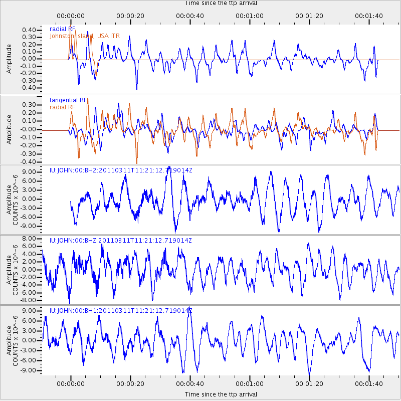
JOHN Johnston Island, USA - Earthquake Result Viewer
*The percent match for this event was below the threshold and hence no stack was calculated.
| Earthquake location: |
Near East Coast Of Honshu, Japan |
| Earthquake latitude/longitude: |
36.4/141.8 |
| Earthquake time(UTC): |
2011/03/11 (070) 11:13:12 GMT |
| Earthquake Depth: |
26 km |
| Earthquake Magnitude: |
5.5 MB |
| Earthquake Catalog/Contributor: |
WHDF/NEIC |
|
| Network: |
IU Global Seismograph Network (GSN - IRIS/USGS) |
| Station: |
JOHN Johnston Island, USA |
| Lat/Lon: |
16.73 N/169.53 W |
| Elevation: |
2.0 m |
|
| Distance: |
47.2 deg |
| Az: |
101.207 deg |
| Baz: |
304.294 deg |
| Ray Param: |
$rayparam |
*The percent match for this event was below the threshold and hence was not used in the summary stack. |
|
| Radial Match: |
60.387505 % |
| Radial Bump: |
400 |
| Transverse Match: |
45.17837 % |
| Transverse Bump: |
349 |
| SOD ConfigId: |
558545 |
| Insert Time: |
2013-09-18 12:11:14.692 +0000 |
| GWidth: |
2.5 |
| Max Bumps: |
400 |
| Tol: |
0.001 |
|
Signal To Noise
| Channel | StoN | STA | LTA |
| IU:JOHN:00:BHZ:20110311T11:21:12.719014Z | 1.1932017 | 3.558609E-6 | 2.9824039E-6 |
| IU:JOHN:00:BH1:20110311T11:21:12.719014Z | 1.1489277 | 3.622655E-6 | 3.1530749E-6 |
| IU:JOHN:00:BH2:20110311T11:21:12.719014Z | 1.837791 | 6.501256E-6 | 3.5375383E-6 |
| Arrivals |
| Ps | |
| PpPs | |
| PsPs/PpSs | |


